Web Service of Map of rockfall source areas, El Hierro (Canary Islands, Spain)


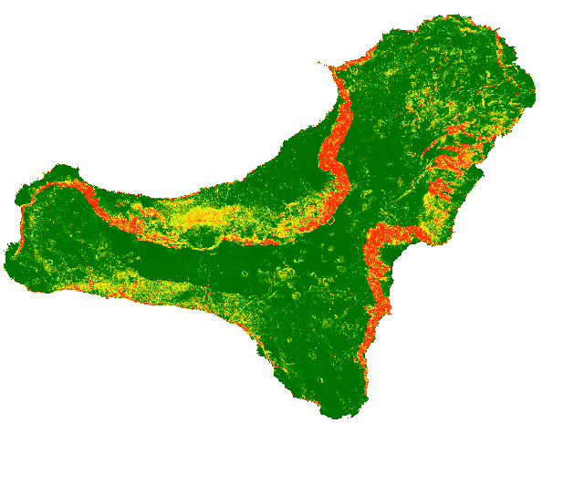
The map shows a probabilistic identification of rockfall source areas for El Hierro Island, prepared with the combination of multiple statistical models
large_thumbnail
service
- Servicio
Rockfall Map Web Service, El Hierro (Canary Islands, Spain)
- URL de acceso
IGME-CSIC
:
WMS_UGEOHAZ_ROCKFALLSOURCEAREAELHIERRO
view
GEMET - INSPIRE themes, version 1.0:
 IGME Thesaurus:
Spatial Scope:
ISO 19119:
ISO - 19119 geographic services taxonomy:
INSPIRE_SpatialDataServicesClassification:
Web Services Specifications:
IGME Thesaurus:
Spatial Scope:
ISO 19119:
ISO - 19119 geographic services taxonomy:
INSPIRE_SpatialDataServicesClassification:
Web Services Specifications:
Rockfalls
Trajectory
Risk
Hazard
Volcanic environment
Canary Islands
IGME
infoMapAccessService
Map Access Service
Geographic model/information management service
WMS (Web Map Service)
WMS 1.3.0
WMS
Free:
EGDI
-18.29,
27.58,
-17.72,
28
publication: 2019-10-28
The map shows on line the probability of each single pixel to be a rock fall source area and can be used as input for rockfall regional modelling in El Hierro (Canary Island)
Geological Survey of Spain (IGME-CSIC)
?
email:
cartografiadigital@igme.es
Role: point of contact
Geological Survey of Spain (IGME-CSIC)
email:
cartografiadigital@igme.es
Role: custodian
Data Quality
Commission Regulation (EU) No 1089/2010 of 23 November 2010 implementing Directive 2007/2/EC of the European Parliament and of the Council as regards the interoperability of spatial data sets and services
COMMISSION REGULATION (EC) No 1205/2008 of 3 December 2008 implementing Directive 2007/2/EC of the European Parliament and of the Council as regards metadata
Constraints
LICENSE FOR USE: Conditions governing the public use and dissemination of the information for the re-use of the IGME data. https://www.igme.es/condiciones-de-uso/
Metadata about metadata
ESPIGMESERVICIOROCKFALLSOURCEAREASELHIERRO20191031
Geological Survey of Spain (IGME-CSIC)
Leticia Vega Martín
Leticia Vega Martín
,
Madrid,
28003,
España
tel: +34 91 349 57 41
email:
l.vega@igme.es
Role: point of contact
2025-05-30