CARTOGRAPHY OF ROCKFALLS SOURCE AREAS IN THE ISLAND OF EL HIERRO, CANARY ISLANDS


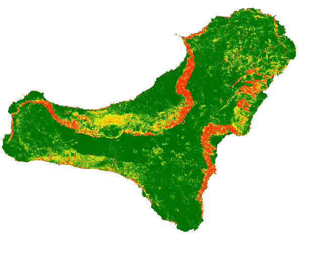
The map shows a probabilistic identification of rockfall source areas for El Hierro Island, prepared with the combination of multiple statistical models. To run the models, we have used observed source areas as dependent variable and a set of thematic information as independent variables (e.g., morphometric parameters derived from the DTM, lithological information that considers the mechanical behaviour of the rocks).
large_thumbnail
dataset
Download of the probabilistic map of rockfalls source areas source in the island of El hierro (Canary Islands)
- Download page from the IGME website
IGME-CSIC
:
ESPIGMEROCKFALLSOURCEAREASELHIERRO
English
Geoscientific information
GEMET - INSPIRE themes, version 1.0:
 IGME Thesaurus:
Spatial Scope:
IGME Thesaurus:
Spatial Scope:
Rockfalls
Trajectory
Risk
Hazard
volcanic environment
Canary Islands
Free:
IGME
Geological hazards
infoMapAccessService
Free:
Geohazards
Free:
EGDI
-18.29,
27.58,
-17.72,
28
creation: 2019-10-15
2019-10-15T10:00:00
completed
grid
The map shows the probability of each single pixel to be a rock fall source area and can be used as input for rockfall regional modelling in El Hierro (Canary Island)
Geological Survey of Spain (IGME-CSIC)
Roberto Sarro Trigueros
,
Madrid,
28003,
España
tel: +34 91 349 59 17
email:
r.sarro@igme.es
Role: author
Geological Survey of Spain (IGME-CSIC)
Rosa María Mateos Ruiz
,
Granada,
18006,
España
tel: +34 958 69 10 21
email:
rm.mateos@igme.es
Role: author
Research Institute for Hydrogeological Protection, National Research Council (CNR-IRPI)
Paola Reichenbach
,
Perugia,
06128,
Italia
tel: +39 075 501 4413
email:
paola.reichenbach@irpi.cnr.it
Role: author
Research Institute for Hydrogeological Protection, National Research Council (CNR-IRPI)
Mauro Rossi
,
Perugia,
06128,
Italia
tel: +39 075 5014421
email:
mauro.rossi@irpi.cnr.it
Role: author
Data Quality
This work has been developed in the framework of the U-GEOHAZ project (Geohazard Impact Assessment for Urban Areas-, funded by the European Commission, Directorate-General Humanitarian Aid and Civil Protection (ECHO), Grant Agreement No. 783169
Equivalent Scale:
1:
25000
, 1:
50000
, 1:
1000000
Commission Regulation (EC) No 1205/2008 of 3 December 2008 laying down detailed rules for the implementation of Directive 2007/2/EC of the European Parliament and of the Council as regards metadata
Constraints
LICENSE FOR USE: Conditions governing the public use and dissemination of the information for the re-use of the IGME data. https://www.igme.es/condiciones-de-uso/
Metadata about metadata
ESPIGMEROCKFALLSOURCEAREASELHIERRO20191031
Geological Survey of Spain (IGME-CSIC)
Leticia Vega Martín
,
Madrid,
28003,
España
tel: +34 91 349 57 41
email:
l.vega@igme.es
Role: point of contact
2026-03-11
Coupled Resource
(The following thematic information have been used as independent variables: slope angle, curvature, lithology, and dyke density. Slope angle and curvature were calculated from the 5-meter DEM derived from LIDAR data provided by the National Geographic Institute (IGN-CNIG). The lithology information, derives from the geological map of the Geological Survey of Spain at 1:25000 scale.)