Service of visualization (WMS) of Ground Movements Map of Spain at scale of 1:1,000,000


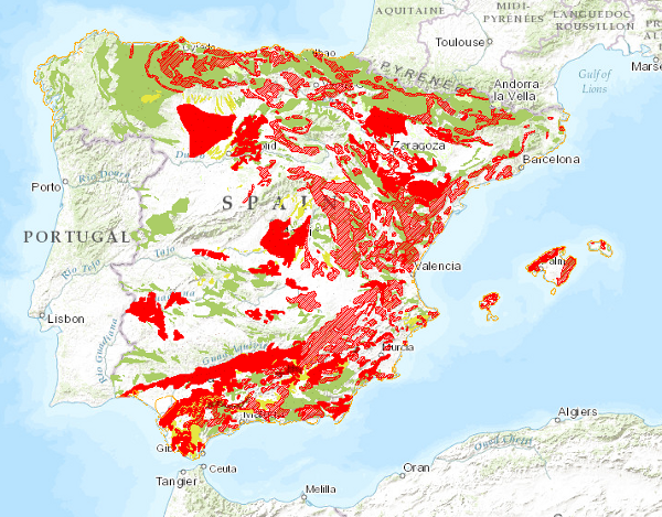
Map showing the geographical distribution of ground movements classified into four main groups: horizontal component in continental areas, vertical component in continental areas, unstable areas linked to coastal areas and movements related to mining operations. Also included are continental areas with important erosive processes.
large_thumbnail
service
- Servicio
Link to GetCapabilities of the web service hosting the product
- URL de acceso
IGME-CSIC
:
WMS_MOVTERRENO1000
view
GEMET - INSPIRE themes, version 1.0:
 Spatial scope:
ISO 19119:
INSPIRE_SpatialDataServicesClassification:
Web Services Specifications:
Spatial scope:
ISO 19119:
INSPIRE_SpatialDataServicesClassification:
Web Services Specifications:
Map access service
infoMapAccessService
Geographic modelling/information management service
infoManagementService
OGC (Open Geospatial Consortium)
WMS (Web Map Service)
WMS 1.3.0
OGC
WMS
Free:
IGME
IDEE
Land Movements
Spain
Free:
IGME
Free:
EGDI
-22.74,
26.578,
6.222,
44.679
creation: 2010-08-16, publication: 2010-08-16
Geological Survey of Spain (IGME-CSIC)
?
email:
cartografiadigital@igme.es
Role: point of contact
Geological Survey of Spain (IGME-CSIC)
email:
cartografiadigital@igme.es
Role: custodian
Data Quality
Commission Regulation (EU) No 1089/2010 of 23 November 2010 implementing Directive 2007/2/EC of the European Parliament and of the Council as regards the interoperability of spatial data sets and services
Constraints
LICENCE OF USE: Conditions of public use and dissemination of information for the re-use of IGME data. https://www.igme.es/condiciones-de-uso/
Metadata about metadata
ESPIGMESERVICIOMOVIMIENTOSDELTERRENO100020120404
Geological Survey of Spain (IGME-CSIC)
Leticia Vega Martín
Leticia Vega Martín
C/ Ríos Rosas, 23,
Madrid,
28003,
España
tel: +34 91 349 57 00
email:
l.vega@igme.es
Role: point of contact
2026-05-22