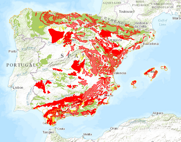
Land Movements Map of Spain at scale of 1:1,000,000


Map delimiting the areas with different types of land movements, representing the most intense and frequent movements. It therefore shows the distribution and extent of the most problematic areas from a practical point of view. Land movements are classified into four main groups: horizontal component movements (landslides and landslides), vertical component movements (subsidence and subsidence, and expansive clays), unstable processes in coastal areas and movements related to mining operations. Areas with significant erosion processes are also included. This map, published in 1987, was drawn up entirely by staff of the Geological Survey of Spain in response to the need for information on geological hazards and risks on a national scale.
large_thumbnail
dataset
- Mapa de Movimientos del Terreno de España a escala 1:1.000.000
Link to the GetCapabilities of the web service hosting the product
- Map service (URL of the Capabilities file)
https://registry.geology.es/id/ESPIGMEMOVIMIENTOSTERRENO1000:
01180, Código del documento en el Centro de documentación del IGME
Spanish
Geoscientific information
INSPIRE_SpatialThemes:
IGME Thesaurus:
CEOLocation:
EuropeanTerritorialUnits:
GEMET:
GEMET - INSPIRE themes, version 1.0:

 Spatial scope:
European Geoscience Registry - Projects:
Spatial scope:
European Geoscience Registry - Projects:
Natural Hazard Zones
General geology
slippage
Quaternary Geomorphology and Geology
mass movement
landslide
Structural geology
subsidence
COUNTRIES
SPAIN
SPAIN
NATURAL ENVIRONMENT, ANTHROPIC ENVIRONMENT
LITHOSPHERE (soil, geological processes)
geological processes
-18.208,
27.608,
4.315,
43.834
creation: 1987-01-01, publication: 1989-01-01, revision: 2003-06-02
completed
vector
Land movements can affect society in different ways, endangering people's safety, destroying buildings or disabling infrastructures; they therefore constitute a geological risk. Spain, due to its rugged relief, climatic conditions and geological characteristics, is a country where this type of phenomena constitutes a real threat. The Spanish Land Movement Map at a scale of 1:1,000,000, in addition to constituting an inventory of spatial distribution, has been drawn up as a first-rate reference for territorial planning at national and regional level in terms of geological risks, allowing an effective approximation for more detailed studies.
Joaquín Mulas de la Peña
C/Ríos Rosas, 23,
Madrid,
28003,
España
email:
j.mulas@igme.es
Role: point of contact
Data Quality
The map was drawn up from the compilation of cartographic information at scales 1:25,000, 1:50,000 and 1:200,000 produced by the IGME, unpublished cartography, Doctoral Theses, Dissertations and other published works. Subsequently, the phenomena to be included in the cartography were established and the legend of surface formations was drawn up. Next, the processes of synthesis, reclassification, generalisation and exaggeration were carried out for the final production of the map. The digitisation process was carried out in 1991 from the printing plates and the definitive normalisation and generation of symbolised files (.lyr) and cartography, in version 8.3 of ArcGis, in 2003.
Equivalent Scale:
1:
1000000
Constraints
LICENCE OF USE: Conditions of public use and dissemination of information for the re-use of IGME data. https://www.igme.es/condiciones-de-uso/
Metadata about metadata
ESPIGMEMOVIMIENTOSTERRENO10002012012001180
Leticia Vega Martín
C/Ríos Rosas, 23,
Madrid,
28003,
España
email:
l.vega@igme.es
Role: point of contact
2026-03-24