WMS of the Geological Map of the Iberian Peninsula, Balearic and Canary Islands at 1M scale of the Geological Survey of Spain


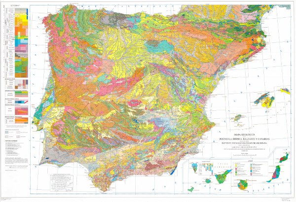
Geological map of the Iberian Peninsula, Balearic and Canary Islands at 1M scale. It includes the chronolithostratigraphic units and the representation of the tectonic structure by means of faults and thrusts.
large_thumbnail
service
- Servicio
view
ISO 19119:
ISO - 19119 geographic services taxonomy:
GEMET - INSPIRE themes, version 1.0:

infoMapAccessService
Servicio de acceso a mapas
Free:
IGME
DEE
Geological Map
Free:
EGD
-22.72,
26.60,
6.25,
44.66
creation: 2009-03-01
Geological Survey of Spain (IGME)
email:
cartografiadigital@igme.es
Role: point of contact
Geological Survey of Spain (IGME)
email:
cartografiadigital@igme.es
Role: custodian
Data Quality
Constraints
LICENCE OF USE: Conditions of public use and dissemination of information for the re-use of IGME data.http://www.igme.es/Ayuda/CondiUso.htm
Metadata about metadata
ESPIGMESERVICIOGEOLOGICO1000EDICION19952011021426047
Geological Survey of Spain (IGME)
Gómez Sánchez, Margarita
Gómez Sánchez, Margarita
C/ Ríos Rosas, 23,
Madrid,
28003,
España
tel: +34 91 349 57 00
email:
m.gomez@igme.es
Role: point of contact
2022-10-14