Geological Map of the Iberian Peninsula, Balearic and Canary Islands, scale 1:1,000,000, 1995 edition.


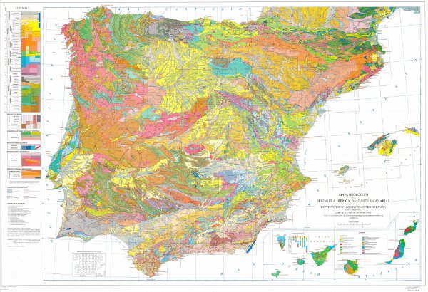
The Geological Map of the Iberian Peninsula, Balearic and Canary Islands or Geological Map of Spain at a scale of 1:1,000,000 is a map developed by the Geological Survey of Spain (IGME) on a cyclical basis since its foundation, being the 1995 version the first to be digitised. This map is an infrastructure of homogeneous and global geological knowledge of a geological unit of continental scale such as the Iberian Peninsula. The map contains the chronolithostratigraphic units with representation of the tectonic structure by means of faults and thrusts. It is also accompanied by two chronolithostratigraphic legends (Peninsula and Balearic and Canary Islands) and the conventional signs. Each of the geological units has an associated description, the dominant rock types and the chronostratigraphic age with precision down to the Flo, when available. There is no difference between the contacts of the map units, all of them being considered as lithological contacts, with the exception of those that are the product of faults. The map is consistent with a topographic base at a scale of 1:1,000,000 prior to the BCN 1000 of the IGN, which is only available in paper format. The geological information on the Iberian Peninsula and the Balearic Islands is in UTM projection, zone 30, Postdam datum. The information on the Canary Islands is in UTM projection, zone 28, datum Pico de las Nieves. The map is distributed free of charge in shape format through the IGME website.
large_thumbnail
dataset
- Mapa Geológico de la Península Ibérica, Baleares y Canarias a escala 1:1.000.000, edición 1995
:
26047
IGME
:
Litologias_color_Geologico_1M
IGME
:
Litologias_tramas_Geologico_1M
IGME
:
Contactos_y_Fallas_Geologico_1M
IGME
:
Indicadores_litologicos_Geologico_1M
Spanish
Geoscientific information
IGME Thesaurus:
GEMET:
GEMET - INSPIRE themes, version 1.0:
 Spatial scope:
Geología general.geología
Stratigraphy.lithostratigraphy
Stratigraphy.Chronostratigraphy
General geology.lithology
Systematics of metamorphic rocks.metamorphic rock
General geology.rock.crystalline rock.igneous rock)
General geology.tectonite
Structural geology.fault
Systematics of Geography.Spain
General geology.rock.sedimentary rock
General geology.contact
Systematics of Stratigraphy.Precambrian
Systematics of stratigraphy.Palaeozoic
Systematics of Stratigraphy.Mesozoic
Systematics of stratigraphy.Cenozoic
Systematic Stratigraphy.Quaternary
NATURAL ENVIRONMENT, ANTHROPIC ENVIRONMENT
LITHOSPHERE (soil, geological processes)
lithosphere
rocKs
Free:
EGDI
-18.25,
27.50,
4.30,
43.75
creation: 1994-01-01, publication: 1995-01-01
1994-01-01T10:00:00
vector
The Geological Map of the Iberian Peninsula, Balearic and Canary Islands synthesises the geological knowledge achieved up to the date of preparation. It is a map with an informative and educational orientation.
Instituto Geológico y Minero de España (IGME-CSIC)
Alejandro Robador Moreno
C/la Calera s/n,
Tres Cantos,
28760,
España
tel: +34 91 349 57 00
email:
a.robador@igme.es
Role: point of contact
Data Quality
The map has been compiled from the compilation of cartographic information at scales 1:25,000, 1:50,000, 1:200,000 and 1:1,000,000 produced by the IGME and other published cartographic and documentary works, together with doctoral theses. The territory was divided into a series of zones according to geological criteria. The corresponding 1:1,000,000 scale synthesis was made for each zone. Finally, the different zones were adjusted and matched, creating the general lithostratigraphic legend and assembling the national map. The digitisation process was carried out in 1996 from the printing plates and the definitive normalisation and generation of symbolised files (.lyr) and cartography, in version 8.3 of ArcGis, in 2003. It should be noted that this map is consistent with a topographic base at a scale of 1:1,000,000 prior to the NGI's BCN 1000, which is only available in paper format.
Equivalent Scale:
1:
200000
Constraints

Nombrar a la fuente: C. N. Instituto Geológico y Minero de España (IGME-CSIC)
Metadata about metadata
ESPIGMEGEOLOGICO1000EDICION19952010072026047
Instituto Geológico y Minero de España (IGME-CSIC)
Leticia Vega Martín
C/ Ríos Rosas, 23,
Madrid,
28003,
España
tel: +34 91 349 57 00
email:
l.vega@igme.es
Role: point of contact
2025-05-09