View Service WMS of Predictive map of risk due to expansive clays in Spain at a scale of 1:1,000,000.


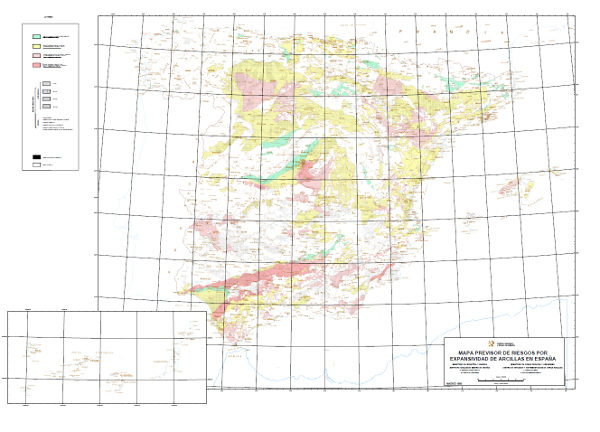
Map with the geographical distribution of the areas where similar expansivity is assumed for the clays, which have been classified into four groups: none to low, low to moderate, moderate to high and high to very high. The different mapped units have been assigned age (4 possible) and lithology (7 different types). The map also shows the surface formations without distinction.
large_thumbnail
service
- Servicio
IGME-CSIC
:
WMS_ARCILLASEXPANSIVAS1000
view
INSPIRE_SpatialDataServicesClassification:
GEMET - INSPIRE themes, version 1.0:

 ISO 19119:
Web Services Specifications:
Spatial scope:
ISO 19119:
Web Services Specifications:
Spatial scope:
Map access service
infoMapAccessService
Geographic modelling/information management service
infoManagementService
OGC (Open Geospatial Consortium)
WMS (Web Map Service)
WMS 1.3.0
OGC
WMS
Free:
IGME
IDEE
Clays
Free:
EGDI
-18.167,
27.642,
4.337,
43.793
publication: 2010-08-16
Geological Survey of Spain (IGME-CSIC)
?
email:
cartografiadigital@igme.es
Role: point of contact
Geological Survey of Spain (IGME-CSIC)
email:
cartografiadigital@igme.es
Role: custodian
Data Quality
Commission Regulation (EU) No 1089/2010 of 23 November 2010 implementing Directive 2007/2/EC of the European Parliament and of the Council as regards the interoperability of spatial data sets and services
Constraints
LICENCE OF USE: Conditions of public use and dissemination of information for the re-use of IGME data. https://www.igme.es/condiciones-de-uso/
Metadata about metadata
ESPIGMESERVICIOARCILLASEXPANSIVAS100020120404
Geological Survey of Spain (IGME-CSIC)
Leticia Vega Martín
C/Ríos Rosas, 23,
Madrid,
28003,
España
tel: +34 91 349 57 00
email:
l.vega@igme.es
Role: point of contact
2026-05-22