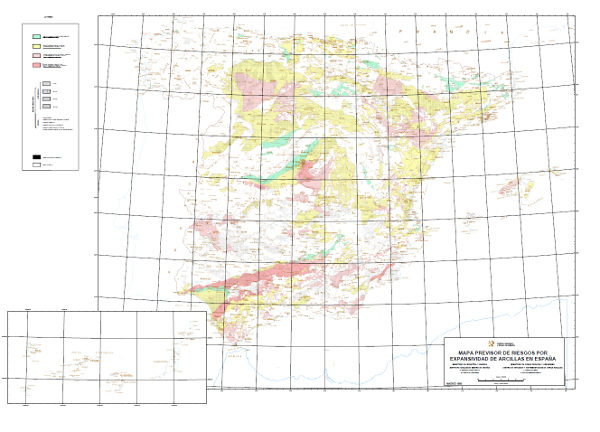
Predictive map of clay expansivity risks in Spain at a scale of 1:1,000,000


The Predictive Map of Expansivity Risks of Spanish Clays at a scale of 1:1,000. 000 delimits the clay formations, classifying them into 4 grades according to their expansivity potential: Non-expansive clays or clays dispersed in a non-clay matrix: No or low risk of expansivity; Subordinate expansive clays or clays located in climatic zones without an annual humidity deficit: Low to moderate expansivity risk; Locally predominant expansive clays located in climatic zones with annual moisture deficit: Moderate to high expansivity risk; Predominant expansive clays in areas where expansivity problems have occurred. High to very high expansivity risk. The term expansivity defines the capacity of the soil to undergo volume changes when its moisture conditions are modified, or to generate pressures if expansion is prevented. This map was made by the Geological Survey of Spain (IGME) with the collaboration of the Centro de Estudios y Experimentación de Obras Públicas (CEDEX) in 1986.
large_thumbnail
dataset
Link to the GetCapabilities of the web service hosting the product
- Map service (URL of the Capabilities file)
:
00947
Spanish
Geoscientific information
CEOLocation:
EuropeanTerritorialUnits:
Thesaurus IGME:
GEMET:
INSPIRE_SpatialThemes:
GEMET - INSPIRE themes, version 1.0:
 Spatial scope:
COUNTRIES
SPAIN
SPAIN
Sedimentary rocks systematics
clay
Environmental Geology
natural hazard
SOCIAL ASPECTS, ENVIRONMENTAL POLICY MEASURES
RISKS, SAFETY
disaster
natural disaster
geological disaster
LAND (landscape, geography)
land
hazard area
NATURAL ENVIRONMENT, ANTHROPIC ENVIRONMENT
LITHOSPHERE (soil, geological processes)
pedosphere
soil
soil capability
soil stability
Natural hazard zones
Free:
EGDI
-18.25,
27.5,
4.5,
43.75
creation: 1986-01-01, publication: 1987-01-01, revision: 2003-01-01
1987-01-01T10:00:00
completed
vector
The construction problems derived from the expansiveness of clay soils can be significant and directly affect the integrity of buildings and certain infrastructures. Spain, due to its climatic conditions and geological characteristics, is a country where this type of phenomenon constitutes a real threat. The 1:1,000,000 scale Predictive Map of Expansive Clay Hazards in Spain, in addition to constituting an inventory of spatial distribution, has been drawn up as a first-order reference for territorial planning at national and regional level in terms of geological/geotechnical risks, providing an effective approximation for more detailed studies.
Geological Survey of Spain (IGME-CSIC)
Mulas de la Peña, Joaquín
C/Ríos Rosa, 23,
Madrid,
28003,
España
tel: +34 91 3495700
email:
j.mulas@igme.es
Role: point of contact
Data Quality
Establishment of territorial spheres with related characteristics (geological, morphological and climatic). Definition and classification of chronolithological units and linkage to climate. Sectorial review and evaluation of expansivity and ascription to the different chronolithological units. Assessment of potential expansivity. Establishment of the expansive potential of the soil and classification. Plotting of units on the map at a scale of 1:1,000,000.
Equivalent Scale:
1:
1000000
REGLAMENTO (CE) Nº 976/2009 DE LA COMISIÓN de 19 de octubre de 2009 por el que se ejecuta la Directiva 2007/2/CE del Parlamento Europeo y del Consejo en lo que se refiere a los servicios de red
COMMISSION REGULATION (EC) No 1205/2008 of 3 December 2008 implementing Directive 2007/2/EC of the European Parliament and of the Council as regards metadata
Constraints
LICENSE OF USE: Conditions of public use and dissemination of information for the reuse of data. https://www.igme.es/condiciones-de-uso/
Metadata about metadata
ESPIGMEEXPANSIVIDADARCILLAS10002012012000947
Instituto Geológico y Minero de España (IGME-CSIC)
Leticia Vega Martín
C/ Ríos Rosas, 23,
Madrid,
28003,
España
tel: +34 91 349 57 00
email:
l.vega@igme.es
Role: point of contact
2025-08-01
Coupled Resource
(Map made as part of the MAGNA Plan as an inventory of the geological knowledge achieved up to 1970.)
(Spatial distribution of cartographic units differentiated by their characteristics and constructive conditions determined on the basis of the lithological composition of the materials, their hydrogeological properties and geomorphological nature. It also includes a zoning or division into homogeneous units based on lithology, stability, bearing capacity and other mechanical and geotechnical properties.)
(Map showing industrial rock deposits and exploitation on a geological and topographical basis.)