Tectonic Map of the Iberian Peninsula and Balearic islands at scale of 1:1,000,000


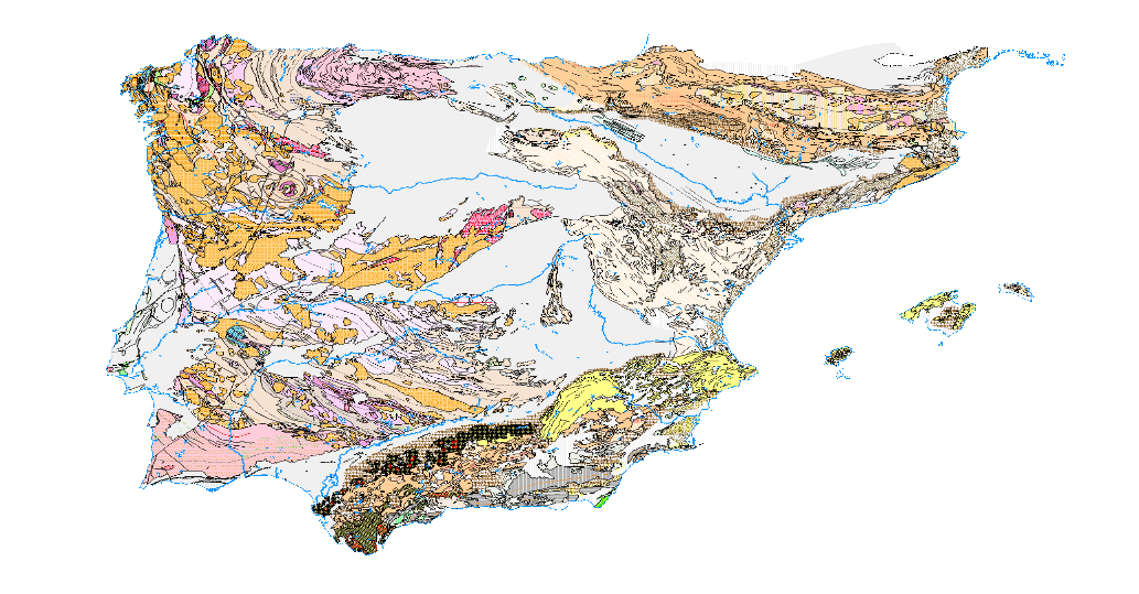
The Tectonic Map of the Iberian Peninsula and Balearic islands has been made according to the guidelines given by the elaboration of the International Tectonic Map of Europe in the 1960s. The principles of representation adopted in this map have a double purpose: to differentiate the major structural elements of the earth's crust, and to record the earth's dynamics in the past. Map of the geographical distribution of the large structural units of the Iberian Peninsula and the Balearic Islands classified into two large groups: platform areas and orogens, from which three units have been derived: Hercynian Mountains, Alpine Mountains and Platform, Mesozoic and Tertiary areas. The cartographic units represented have been delimited based on their temporal relationships with the age of deformation, in the case of the Cordilleras. The structural relations between the units are reflected by the trace of the large folding structures and the faults. The different degrees of metamorphism to which the different rock groups have been subjected are also included.
large_thumbnail
dataset
Download Tectonic Map of Spain 1:1.000.000
- Download page from the IGME website
IGME-CSIC
:
ESPIGMETECTONICO1000
Spanish
Geoscientific information
IGME Thesaurus:
GEMET - INSPIRE themes, version 1.0:
 Spatial Scope:
IGME
Tectonics
Thrust fault
Free:
IDEE
Free:
EGDI
-18.167,
27.642,
4.337,
43.793
creation: 1971-12-01, publication: 1972-01-01
1972-01-01T10:00:00
completed
vector
The representation principles adopted in the aforementioned map have a dual purpose: to differentiate the major structural elements of the Earth's crust and to record the Earth's past dynamism. Geographic distribution map of the major structural units of the Iberian Peninsula and the Balearic Islands, classified into two main groups: platform areas and orogens, from which three units have been derived: the Hercynian Range, the Alpine Ranges, and the Mesozoic and Tertiary Platform Areas. The cartographic units represented have been delimited based on their temporal relationships with the age of deformation, in the case of the mountain ranges. The structural relationships between the units are reflected by the outline of the major fold structures and faults. The different degrees of metamorphism to which the different rock groups have been subjected are also included.
Geological Survey of Spain (IGME-CSIC)
Joaquín Mulas de la Peña
,
Madrid,
28003,
España
tel: + 34 91 349 5811 / 91 349 5952
email:
j.mulas@igme.es
Role: custodian
Data Quality
The Tectonic Map of the Iberian Peninsula and Balearic Islands has been made according to the guidelines given by the elaboration of the International Tectonic Map of Europe in the 1960s. The principles of representation adopted in this map have a double purpose: to differentiate the major structural elements of the earth's crust, and to record the earth's dynamics in the past. Map of the geographical distribution of the large structural units of the Iberian Peninsula and the Balearic Islands classified into two large groups: platform areas and orogens, from which three units have been derived: Hercynian Mountains, Alpine Mountains and Platform, Mesozoic and Tertiary areas. The cartographic units represented have been delimited based on their temporal relationships with the age of deformation, in the case of the Cordilleras. The structural relations between the units are reflected by the trace of the large folding structures and the faults. The different degrees of metamorphism to which the different rock groups have been subjected are also included.
Equivalent Scale:
1:
1000000
COMMISSION REGULATION (EC) No 1205/2008 of 3 December 2008 implementing Directive 2007/2/EC of the European Parliament and of the Council as regards metadata
Constraints
LICENCE OF USE: Conditions of public use and dissemination of information for the re-use of IGME data. https://www.igme.es/condiciones-de-uso/
Metadata about metadata
ESPIGMETECTONICO100020200716
Geological Survey of Spain (IGME-CSIC)
Leticia Vega Martín
C/Ríos Rosas, 23,
Madrid,
28003,
España
email:
l.vega@igme.es
Role: point of contact
2026-05-22