IGME Historical inventory of the IRYDA drillings


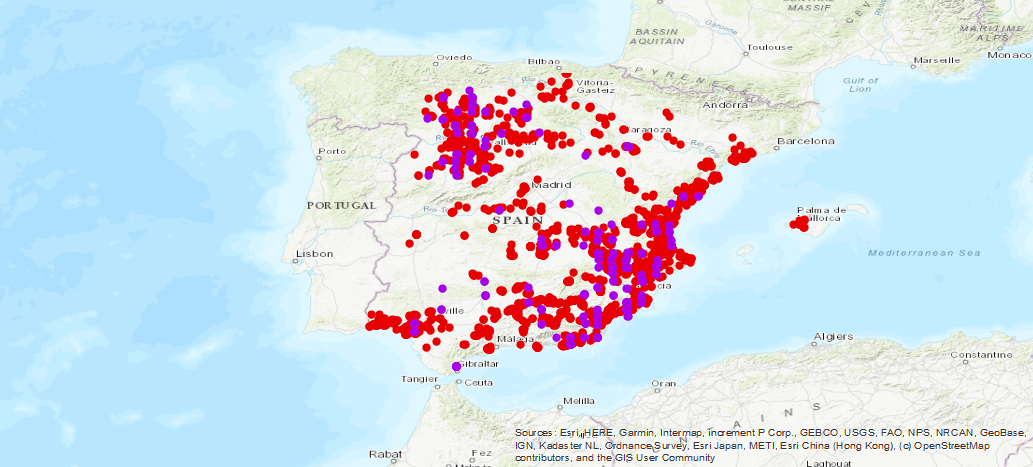
Historical data of the surveys carried out for the investigation of the different aquifers of Spain, the result of the collaboration between the Geological and Mining Institute of Spain (IGME-CSIC), with the National Institute of Agrarian Reform and Development (IRYDA), before the National Institute of Colonization (INC). The surveys were conducted mainly between 1950 and 1990
large_thumbnail
dataset
Visualization of Historical inventory of the IRYDA drillings
- IGME website viewing page
IGME-CSIC
:
ESPIGME_BD_SONDEOSIRYDA
Spanish
Geoscientific information
IGME Thesaurus:
GEMET - INSPIRE themes, version 1.0:
 Spatial Scope:
IGME
WATER
Water Points
Borehole
Hydroeology
lithology
Spain
Free:
IRYDA
INC
Free:
EGDI
-7.799,
36.146,
3.127,
43.156
creation: 1990-01-01
1970-01-01T10:00:00
completed
vector
The IRYDA Survey Database was created with the objective of fundamentally covering the need for simple and fast storage of the volume of data obtained within the collaboration between the IGME and IRYDA, in relation to the knowledge of the underground aquifers of Spain, their potential Hydraulic, mainly from the Underground Water Research Plans (PIAS) and Aquifer Management and Conservation (PGCA) and Urban Nucleus Supply (PANU).
Geological Survey of Spain (IGME-CSIC)
Miguel Mejías Moreno
,
Madrid,
28003,
España
tel: +34 91 349 5744
email:
m.mejias@igme.es
Role: point of contact
Data Quality
Historical data from soundings carried out for the investigation of the different aquifers in Spain, the result of collaboration between the Geological and Mining Institute of Spain (IGME-CSIC), with the National Institute of Agrarian Reform and Development (IRYDA), formerly the National Institute of Colonization (INC). Surveys were carried out mainly between 1950 and 1990. The IRYDA Drilling Database was created with the aim of covering the need for simple and rapid storage of the volume of data obtained within the collaboration between the IGME and IRYDA, in relation to the knowledge of underground aquifers in Spain, their hydraulic potential, mainly from the Research Plans for Groundwater (PIAS) and Aquifer Management and Conservation (PGCA) and Supply to Urban Nuclei (PANU)..
COMMISSION REGULATION (EC) No 1205/2008 of 3 December 2008 implementing Directive 2007/2/EC of the European Parliament and of the Council as regards metadata
Constraints
LICENSE OF USE: Conditions of public use and dissemination of information for the reuse of IGME data. https://www.igme.es/condiciones-de-uso/
Metadata about metadata
ESPIGMESONDEOSIRYDA20190726
Geological Survey of Spain (IGME-CSIC)
Leticia Vega Martín
Leticia Vega Mártín
,
Madrid,
28003,
España
tel: +34 91 349 57 00
email:
l.vega@igme.es
Role: point of contact
2026-05-22
Coupled Resource
(The main sources of information were the Groundwater Research Plan (PIAS) and the Aquifer Management and Conservation Plan (PGCA) and the Urban Core Supply Plan (PANU).)