Service of visualization (WMS) of Permeability Map of Spain at scale of 1:1,000,000


Lithostratigraphic Map of Spain classified according to permeability
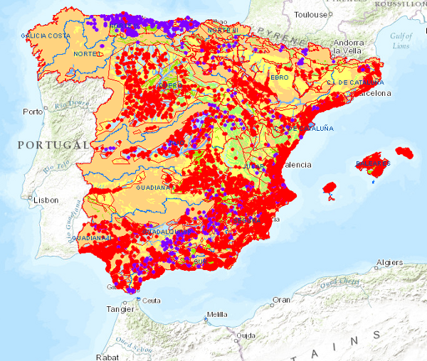
large_thumbnail
service
- Servicio
Link to GetCapabilities of the web service hosting the product
- URL de acceso
IGME-CSIC
:
WMS_PERMEABILIDAD1000
view
GEMET - INSPIRE themes, version 1.0:
 IGME Thesaurus:
CEOLocation:
Spatial scope:
ISO 19119:
INSPIRE_SpatialDataServicesClassification:
Web Services Specifications:
IGME Thesaurus:
CEOLocation:
Spatial scope:
ISO 19119:
INSPIRE_SpatialDataServicesClassification:
Web Services Specifications:
Physical and chemical properties
properties
physical properties
permeability
COUNTRIES
SPAIN
Map access servicel
infoMapAccessService
Geographic modelling/information management service
infoManagementService
OGC (Open Geospatial Consortium)
WMS (Web Map Service)
WMS 1.3.0
OGC
WMS
Free:
IGME
IDEE
Spain
ewater
Free:
EGDI
-22.717,
26.602,
6.218,
44.66
publication: 2009-03-01
Geological Survey of Spain (IGME-CSIC)
?
email:
cartografiadigital@igme.es
Role: point of contact
Geological Survey of Spain (IGME-CSIC)
email:
cartografiadigital@igme.es
Role: custodian
Data Quality
Commission Regulation (EU) No 1089/2010 of 23 November 2010 implementing Directive 2007/2/EC of the European Parliament and of the Council as regards the interoperability of spatial data sets and services
Constraints
LICENCE OF USE: Conditions of public use and dissemination of information for the re-use of IGME data. https://www.igme.es/condiciones-de-uso/
Metadata about metadata
ESPIGMESERVICIOPERMEABILIDAD1M20110222621982
Geological Survey of Spain (IGME-CSIC)
Leticia Vega Martín
Leticia Vega Martín
C/ Ríos Rosas, 23,
Madrid,
28003,
España
tel: +34 91 349 57 00
email:
l.vega@igme.es
Role: point of contact
2026-05-22