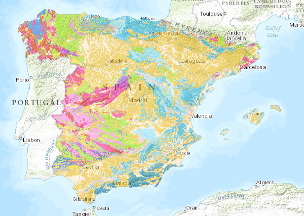
Visualization service (WMS) of the lithological map of the Iberian Peninsula, Balearic and Canary islands at a scale of 1:1,000,000


The lithological map at a scale of 1:1,000,000 has been obtained by assigning the most representative lithology or lithological association to each cartographic unit on the map. It has been based on the original classification of the edited map, which has been subsequently revised, giving rise to the current classification.
large_thumbnail
service
- Servicio
IGME-CSIC
:
WMS_LITOLOGICO1000
view
GEMET - INSPIRE themes, version 1.0:
 CEOLocation:
Spatial scope:
ISO 19119:
INSPIRE_SpatialDataServicesClassification:
Web Services Specifications:
CEOLocation:
Spatial scope:
ISO 19119:
INSPIRE_SpatialDataServicesClassification:
Web Services Specifications:
COUNTRIES
SPAIN
Map access service
infoMapAccessService
Servicio de gestión de modelos/información geográficos
infoManagementService
OGC (Open Geospatial Consortium)
WMS (Web Map Service)
WMS 1.3.0
OGC
WMS
Free:
IGME
IDEE
Spain
Lithologies
Free:
EGDI
-22.719,
26.602,
6.257,
44.66
publication: 2009-03-01
Geological Survey of Spain (IGME-CSIC)
?
email:
cartografiadigital@igme.es
Role: point of contact
Geological Survey of Spain (IGME-CSIC)
email:
cartografiadigital@igme.es
Role: custodian
Data Quality
Commission Regulation (EU) No 1089/2010 of 23 November 2010 implementing Directive 2007/2/EC of the European Parliament and of the Council as regards the interoperability of spatial data sets and services
Constraints
LICENCE OF USE: Conditions of public use and dissemination of information for the re-use of IGME data. https://www.igme.es/condiciones-de-uso/
Metadata about metadata
ESPIGMESERVICIOLITOLOGICO100020110216260471
Geological Survey of Spain (IGME-CSIC)
Leticia Vega Martín
C/ Ríos Rosas, 23,
Madrid,
28003,
España
tel: +34 91 349 57 00
email:
l.vega@igme.es
Role: point of contact
2026-05-22