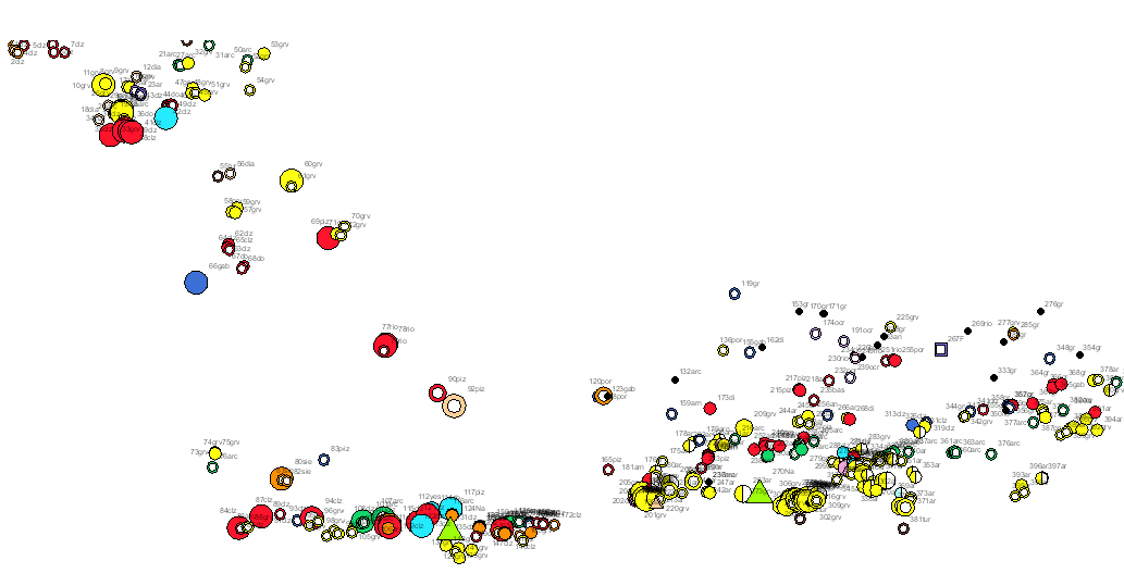
Service of visualization (WMS) of the Map of Map of rocks and industrial minerals of the South Portuguese Zone. Scale 1:400.000. 2020 edition.


Rocks and industrial minerals map in the South Portuguese Zone, on a scale of 1:400,000, which, on a harmonised geological basis, with unified criteria between Spain and Portugal, has represented the main exploitations and indications of rocks and industrial minerals in the area, indicating their state (active, abandoned or intermittent), size, use and substance. This cartography is a product of the project GEO_FPI: Cross-border Observatory for the geo-economic exploitation of the Iberian Pyrite Belt, co-financed by ERDF funds through the INTERREG POCTEP 2014-2020 territorial cooperation programme. The main beneficiary of the project is the Geological Survey of Spain (IGME-CSIC). The partnership for this project includes the Directorate-General for Industry, Energy and Mines of the Ministry of Finance, Industry and Energy of the Andalusian Regional Government (DGIEM), the National Laboratory of Energy and Geology, I.P. (LNEG) and the Municipal Chamber of Aljustrel (CMA).
large_thumbnail
service
- Servicio
IGME-CSIC
:
WMS_GEOPFI_RYMI400
view
GEMET - INSPIRE themes, version 1.0:
 Spatial scope:
IGME Thesaurus:
ISO 19119:
Web Services Specifications:
ISO - 19119 geographic services taxonomy:
INSPIRE_SpatialDataServicesClassification:
Spatial scope:
IGME Thesaurus:
ISO 19119:
Web Services Specifications:
ISO - 19119 geographic services taxonomy:
INSPIRE_SpatialDataServicesClassification:
Alentejo
Algarve
Andalusia
Cartography
Geology
Chronostratigraphy
Mineral localities
Massive sulfide deposits
Mines
Quarries
Spain
Portugal
OGC (Open Geospatial Consortium)
WMS (Web Map Service)
WMS 1.3.0
OGC
infoMapAccessService
Map access service
Geographic modelling/information management service
Free:
400K
Free:
Mineração
Free:
Metallogenetic map
Free:
Industrial rocks and minerals
Free:
Iberian Pyritic Belt
Free:
Surportuguese zone
Free:
IGME
Free:
LNEG
Free:
EGDI
Free:
WMS
-9.677,
36.97,
-5.566,
38.77
creation: 2020-12-23
Providing information about the mining operations and deposit of industrial rocks and minerals present in the Geological Domain of the South-Portuguese Zone (SPZ) and SW Iberia Mesozoic and Cenozoic basins. The information focuses on the type of mineral commodity, the state of the activity and magnitude, and the destination of the resource
Geological Survey of Spain (IGME-CSIC)
email:
cartografiadigital@igme.es
Role: point of contact
Geological Survey of Spain (IGME-CSIC)
email:
cartografiadigital@igme.es
Role: custodian
Data Quality
Commission Regulation (EU) No 1089/2010 of 23 November 2010 implementing Directive 2007/2/EC of the European Parliament and of the Council as regards the interoperability of spatial data sets and services
COMMISSION REGULATION (EC) No 1205/2008 of 3 December 2008 implementing Directive 2007/2/EC of the European Parliament and of the Council as regards metadata
Constraints
LICENCE OF USE: Conditions of public use and dissemination of information for the re-use of IGME data. https://www.igme.es/condiciones-de-uso/
Metadata about metadata
ESPIGMESERVICIOGEOFPIROCASMINERALESEINDUSTRIAES400202119
Geological Survey of Spain (IGME-CSIC)
Leticia Vega Martín
,
Madrid,
28003,
España
tel: +34 91 349 57 41
email:
l.vega@igme.es
Role: point of contact
2025-08-08