Visualisation Service (WMS) of the Mineral Resources Database (Industrial rocks and minerals)


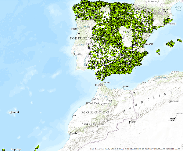
The Service consists of two point layers that symbolize the location of the indications or exploitations of Industrial Rocks and Minerals for the entire national territory. Depending on the display scale, two point layers have been created. Exploitation I: represents only the location of the points. Visible from scales smaller than 1:200,000. Exploitation II: represents the location of the points with symbolization based on different attributes. Visible from scales larger than 1:200,000.
large_thumbnail
service
- Servicio
IGME-CSIC
:
WMS_BDMIN_RYMI
view
GEMET - INSPIRE themes, version 1.0:

 Minerals Intelligence Network for Europe register 1.0, 2014:
European Geoscience Registry - Projects:
ISO - 19119 geographic services taxonomy, 1.0:
Especificación de servicios Web:
ISO 19119:
Minerals Intelligence Network for Europe register 1.0, 2014:
European Geoscience Registry - Projects:
ISO - 19119 geographic services taxonomy, 1.0:
Especificación de servicios Web:
ISO 19119:
Explotaciones subterráneas y a cielo abierto
Cantera
Productos Minerales
Minerales no metálicos
Yacimiento mineral
Explotación activa continua
Explotación abandonada
Minerals4EU
Map access service
Geographic model/information management service
infoMapAccessService
infoManagementService
OGC
Wms
1.3.0
Free:
EGDI
-19.059,
26.981,
5.425,
44.551
revision: 2014-05-01
Research Group on Economic Geology of Mineral Resources (Gi-Gecomin).
?
email:
s.timon@igme.es
Role: resource provider
Geological Survey of Spain (IGME-CSIC)
email:
cartografiadigital@igme.es
Role: custodian
Data Quality
Constraints
LICENCE OF USE: Conditions of public use and dissemination of information for the re-use of IGME data. https://www.igme.es/condiciones-de-uso/
Metadata about metadata
ESPIGMESERVICIOBDMINRYMI2015020613_1
Geological Survey of Spain (IGME-CSIC)
Leticia Vega Martín
Leticia Vega Martín
,
Madrid,
28003,
España
tel: +34 91 349 57 00
email:
l.vega@igme.es
Role: point of contact
2026-05-22