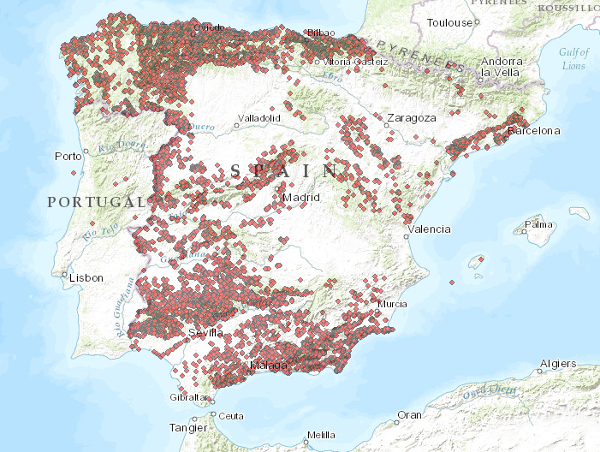
Visualisation Service (WMS) of the Mineral Resources Database (Metallogeny)


The service consists of two layers of dots symbolising the position of mineral occurrences for the entire national territory. Depending on the scale of visualisation, two layers of information have been created. Indications I: Only the location of the points is represented. Visible from scales smaller than 1:200.000. Indications II: The points are represented with a symbolisation according to different attributes. Visible from scales larger than 1:200,000. The reference systems offered by this service are:CRS:84, EPSG:4326, EPSG:4258, EPSG:4230, EPSG:23028, EPSG:23029, EPSG:23030, EPSG:23031, EPSG:25828, EPSG:25829, EPSG:25830, EPSG:25831
large_thumbnail
service
- Servicio
IGME-CSIC
:
WMS_BDMIN_METALOGENIA
view
GEMET - INSPIRE themes, version 1.0:
 GEMET - Supergroups, groups and concepts:
CEOLocation:
IGME Thesaurus:
Minerals Intelligence Network for Europe register 1.0, 2014:
European Geoscience Registry - Projects:
Spatial Scope:
INSPIRE_SpatialDataServicesClassification:
ISO - 19119 geographic services taxonomy, 1.0:
ISO 19119:
Web Services Specifications:
ISO 19119:
GEMET - Supergroups, groups and concepts:
CEOLocation:
IGME Thesaurus:
Minerals Intelligence Network for Europe register 1.0, 2014:
European Geoscience Registry - Projects:
Spatial Scope:
INSPIRE_SpatialDataServicesClassification:
ISO - 19119 geographic services taxonomy, 1.0:
ISO 19119:
Web Services Specifications:
ISO 19119:
Mineral resources
COUNTRIES
SPAIN
Metallogenic map
Metallogeny
Mineral
Recursos minerales
Map of mineral deposits
Thematic cartography
Metallothec
Mining indications
Mineral deposits
Base metals
Metallic minerals
Mineral Deposit
Indications
Map access service
Geographic model/information management service
infoMapAccessService
infoManagementService
Map access service
Geographic model/information management service
infoMapAccessService
infoManagementService
OGC
wms
1.3.0
Free:
WMS, IGME, Mining Indices
Free:
EGDI
-9.792,
35.813,
3.325,
44.124
revision: 2014-05-01
Research Group on Economic Geology of Mineral Resources (Gi-Gecomin).
?
email:
s.timon@igme.es
Role: resource provider
Geological Survey of Spain (IGME-CSIC)
email:
cartografiadigital@igme.es
Role: custodian
Data Quality
Commission Regulation (EU) No 1089/2010 of 23 November 2010 implementing Directive 2007/2/EC of the European Parliament and of the Council as regards interoperability of spatial data sets and spatial data services
Constraints
LICENCE OF USE: Conditions of public use and dissemination of information for the re-use of IGME data. https://www.igme.es/condiciones-de-uso/
Metadata about metadata
ESPIGMESERVICIOBDMINMETALOGENIA2015020613_2
Geological Survey of Spain (IGME-CSIC)
Leticia Vega Martín
C/Ríos Rosas, 23,
Madrid,
28003,
España
tel: (+34) 91 349 57 41
email:
l.vega@igme.es
Role: point of contact
2026-05-22