CARTOGRAPHY OF ROCKFALLS SUSCEPTIBILITY IN THE ISLAND OF EL HIERRO, CANARY ISLANDS


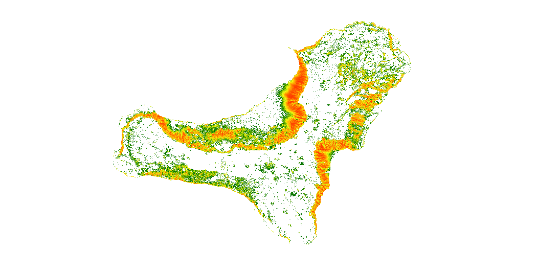
The map show the number of trajectories that pass through each pixel.
large_thumbnail
dataset
Download of the map of rockfall trajectories simulation in the island of El Hierro, Canary Islands
- Download page from the IGME website
IGME-CSIC
:
ESPIGMEROCKFALLSTRAJECTORIESELHIERRO
English
Geoscientific information
GEMET - INSPIRE themes, version 1.0:
 Tesauro IGME:
SpatialScope:
Tesauro IGME:
SpatialScope:
Rockfalls
Trajectory
Risk
Hazard
volcanic environment
Canary Islands
Free:
IGME
Geological hazards
infoMapAccessService
Free:
Geohazards
Free:
EGDI
-18.29,
27.58,
-17.72,
28
creation: 2019-10-15
2019-10-15T10:00:00
completed
grid
The data may be used as input to calculate rockfalls risk on the island of El Hierro (Canary Islands), and to estimate the potential economic losses.
Geological Survey of Spain (IGME-CSIC)
Roberto Sarro Trigueros
,
Madrid,
28003,
España
tel: +34 91 349 5917
email:
r.sarro@igme.es
Role: author
Geological Survey of Spain (IGME-CSIC)
Rosa María Mateos Ruiz
,
Granada,
18006,
España
tel: +34 958 69 1021
email:
rm.mateos@igme.es
Role: author
Research Institute for Hydrogeological Protection, National Research Council (CNR-IRPI)
Paola Reichenbach
,
Perugia,
06128,
Italia
tel: +39 075 501 4413
email:
paola.reichenbach@irpi.cnr.it
Role: author
Research Institute for Hydrogeological Protection, National Research Council (CNR-IRPI)
Mauro Rossi
,
Perugia,
06128,
Italy
tel: +39 075 5014421
email:
mauro.rossi@irpi.cnr.it
Role: author
Data Quality
This work has been developed in the framework of the U-GEOHAZ project (Geohazard Impact Assessment for Urban Areas), funded by the European Commission, Directorate-General Humanitarian Aid and Civil Protection (ECHO), Grant Agreement No. 783169.
Equivalent Scale:
1:
25000
, 1:
50000
, 1:
1000000
Commission Regulation (EC) No 1205/2008 of 3 December 2008 laying down detailed rules for the implementation of Directive 2007/2/EC of the European Parliament and of the Council as regards metadata
Constraints
LICENSE FOR USE: Conditions governing the public use and dissemination of the information for the re-use of the IGME data. https://www.igme.es/condiciones-de-uso/
Metadata about metadata
ESPIGMEROCKFALLSTRAJECTORIESELHIERRO20191031
Geological Survey of Spain (IGME-CSIC)
Leticia Vega Martín
,
Madrid,
28003,
España
tel: +34 91 349 57 41
email:
l.vega@igme.es
Role: point of contact
2026-03-11
Coupled Resource
(This map represents the areas with higher rockfall susceptibility. The data was derived from terrain and geological information. The input DEM was generated by the National Geographic Institute at a 5m x 5m resolution. According to the available National Geological Continuous Map of Spain (GEODE) from IGME (www.igme.es), lithological units were differentiated and their coefficients were obtained.)