Permeability Map of Spain at scale 1:200.000 digital continuous


The continuous and digital Permeability Map of Spain at a scale of 1:200.000000 is based on the continuous Lithostratigraphic Map of Spain at a scale of 1:200.000 and represents the mapped lithostratigraphic levels grouped by similar permeability values.
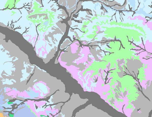
In order to carry it out, firstly, a legend was drawn up in which a degree of permeability was assigned to each mapped lithostratigraphic unit. Five types of permeability were established: Very high, High, Medium, Low and Very low. The different lithologies were associated into 7 large groups (carbonate, detrital, Quaternary detrital, volcanic, metadetritic, igneous and evaporitic), giving rise to a classification by types of aquifers, established according to the formation processes of each permeability.
This map clearly shows the hydrogeological domains with a predominance of calcareous and evaporitic, detritic and crystalline aquifers, highlighting the main peninsular and island structural lines that bring the different groundwater bodies defined into contact with each other.
This cartography is adapted to the hydrographic network and the shadow model produced by CEDEX, at a scale of 1:200,000, based on the topographic base, at a scale of 1:50,000, of the Army Cartographic Service. The cartographic information is referenced to coordinates in UTM projection, European Datum, zone 30, except for that corresponding to the Canary Islands, which is referenced to zone 28.
The map is made up of the Cartographic Units Information Layer (LPIT) and the external table
dat table, which assigns to each lithostratigraphic formation (FH) the degree of permeability as well as the colour of representation.
The format of the generated information is Shape file.
large_thumbnail
dataset
- ?
Link to the GetCapabilities of the web service hosting the product
- Map service (URL of the Capabilities file)
:
637842
Spanish
Geoscientific information
Tesauro IGME:
CEOLocation:
GEMET:
GEMET - INSPIRE themes, version 1.0:
 Spatial scope:
Stratigraphy.lithostratigraphy
Stratigraphy.lithostratigraphy
Hydrology, Hydrogeology, Hydrogeology.
COUNTRIES.SPAIN
NATURAL ENVIRONMENT, ANTHROPIC ENVIRONMENT
HYDROSPHERE (freshwater, seawater, waters)
hydrosphere
water (geography)
groundwater
Free:
Chronostratigraphy
Free:
Permeability
Free:
groundwater
Free:
WFD
Free:
Groundwater body
Free:
Aquifer
Free:
EGDI
-18.25,
27.50,
4.50,
43.75
creation: 2005-09-18, publication: 2007-09-30, revision: 2009-08-05
2009-08-05T00:00:00
completed
vector
The Permeability Map allows the representation of the hydrogeological information at a scale of 1:200,000 for most of the groundwater bodies defined. In the case of small bodies of groundwater, although this scale of representation may present disadvantages in terms of definition, it does allow a certain amount of detail to show their hydrogeological functioning and to be able to programme detailed studies when necessary.
The continuous lithostratigraphic and permeability map of Spain, at a scale of 1:200,000, is produced by means of a "Collaboration Agreement between the Ministry of the Environment (General Secretariat for Territory and Biodiversity. Directorate General for Water) and the Geological and Mining Institute of Spain for the performance of technical work in relation to the application of the Water Framework Directive on groundwater" signed in 2004, and is the basis for the preparation of the Hydrogeological Map of Spain at a scale of 1:200,000 continuous and in digital format.
The continuous lithostratigraphic and permeability map of Spain, at a scale of 1:200,000, is produced by means of a "Collaboration Agreement between the Ministry of the Environment (General Secretariat for Territory and Biodiversity. Directorate General for Water) and the Geological and Mining Institute of Spain for the performance of technical work in relation to the application of the Water Framework Directive on groundwater" signed in 2004, and is the basis for the preparation of the Hydrogeological Map of Spain at a scale of 1:200,000 continuous and in digital format.
Geological Survey of Spain (IGME-CSIC)
Mejías Moreno, Miguel
C/ Ríos Rosas, 23,
Madrid,
28003,
España
tel: +34 91 349 57 00
email:
m.mejias@igme.es
Role: point of contact
Data Quality
The permeability map has been made on the basis of the information generated for the lithostratigraphic map of Spain at a scale of 1:200,000 continuous. From here, different processes are differentiated:
1.- Elaboration of a permeability legend that assigns a degree of permeability to each lithostratigraphic unit.
2.- Elaboration of the permeability map, in which the mapped lithostratigraphic levels with similar permeability values were grouped together.
1.- Elaboration of a permeability legend that assigns a degree of permeability to each lithostratigraphic unit.
2.- Elaboration of the permeability map, in which the mapped lithostratigraphic levels with similar permeability values were grouped together.
Equivalent Scale:
1:
200000
Specifications for the digitisation of hydrogeological mapping
Constraints
LICENCE OF USE: Conditions of public use and dissemination of information for the re-use of IGME data. https://www.igme.es/condiciones-de-uso/
Metadata about metadata
ESPIGMEPERMEABILIDADES200CONTINUODIGITAL20100805637842
Geological Survey of Spain (IGME-CSIC)
Leticia Vega Martín
C/ Ríos Rosas, 23,
Madrid,
28003,
España
tel: +34 91 349 57 41
email:
l.vega@igme.es
Role: point of contact
2025-05-16