Geologic Map of Spain 1:50.000 scale, MAGNA


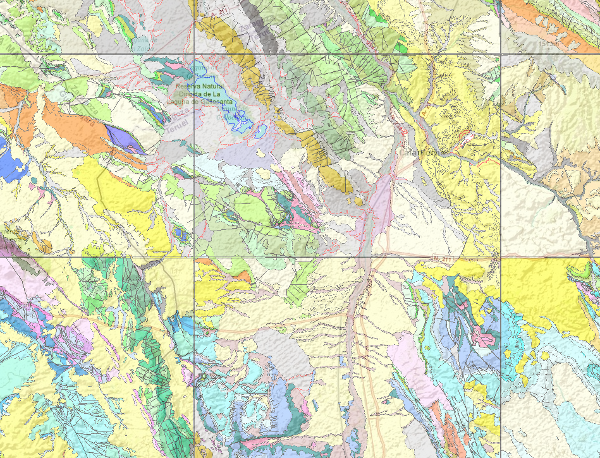
The National Geological Map (MAGNA), was made between 1972 and 2003 by the Geological Survey of Spain, is distributed in sheets 1: 50.000 (1: 25.000 in particular cases of the Canary Islands, Ibiza-Formentera, Menorca, Ceuta and Melilla). The geological map shows the nature of materials (rocks and sediments) that appear on the surface, their spatial distribution and geometric relationships between the different cartographic units represented.
A geological mapping unit is the grouping of one or more lithologies with common age range, which is represented on the map at a scale or defined resolution. Each mapping unit, and the different geological structures, is represented on the map with a symbolism itself. The representation of these units on the topographic base map provides some three-dimensional information that is completed with other geological data and geological sections, stratigraphic profiles, polls, etc. The map legend is a pictogram representing the spatial relationship of the different mapping units (chronology, overlapping, geometric relationship, lateral facies changes, etc.). It also includes structural, hydrogeological and geological location of the sheet within the regional schemes.
Since 1991, the Geological Map Series MAGNA is made inseparably with the geomorphological map on the same scale. This map incorporates everything on the surface geology and provides a structured and accurate information of the land forms. It is organized on the basis of morphogenesis and morphocronology incorporated the map using the corresponding chronostratigraphic column included in a table / legend inspired by the geological map. The forms, erosional and depositional, are represented on the map by individualized by symbols and patterns of color and surface deposits or lithological formations elements that provide information.
For each sheet of the series MAGNA there is an explanatory report published, edited and in digital format.
The digital information is stored in coverage and Shape format (ESRI). There is a guide that describes the physical structure of the digital information and its codification.
large_thumbnail
series
- Mapa Geológico de España Escala 1:50.000. MAGNA
:
Código documento en el servicio de documentación: 20000
https://registry.geology.es/id/ESPIGMEMAGNA50
Spanish
Geoscientific information
IGME Thesaurus:
GEMET:
GEMET - INSPIRE themes, version 1.0:
 Spatial scope:
Geology
Estratigrafía.litoestratigrafía
Estratigrafía.cronoestratigrafía
Geología general.tectonita
Geomorfología y Geología del Cuaternario.geomorfología
Geomorfología y Geología del Cuaternario.morfogénesis
Geomorfología y Geología del Cuaternario.formación superficial
Geomorfología y Geología del Cuaternario.mapa geomorfológico
Geología general.mapa geológico
NATURAL ENVIRONMENT, ANTHROPIC ENVIRONMENT
LITHOSPHERE (soil, geological processes)
lithosphere
rocks
Free:
Spain
EGDI
InventoryGM
-18.168,
27.584,
4.482,
43.834
creation: 1972-01-01, publication: 1972-01-01, revision: 1991-01-01
under development
vector
The Geological Map of Spain (MAGNA) 1: 50,000 scale (including geomorphological map) is part of the infrastructure of geoscientific knowledge for socio-economic development. Supports activities such as hydro-geological and mineral resources, public works, agriculture, land use, the environment territorial planning, natural hazards and generally any action on the physical environment that supports the decision-making actions on the territory.
Geological Survey of Spain
?
email:
cartografiadigital@igme.es
Role: author
Data Quality
The realization of this geological cartography is based on the geological information from the incomplete Geological Map of Spain scale 1: 50,000 (first series). In addition it collects and analyzes other information concerning the area and its environment, including bases and other topographic mapping and related work as singular projects, doctoral dissertations, etc.
The next step is the collection of data and samples for later study. After the transfer of field work to map, photo-interpretation work supported, and the final composition of the geological map.
This cartography is completed with the elaboration of the text of memory and organization and classification of additional information.
The digitization of the geological mapping information and normalization is in accordance with the Rules of digitization and Normalization defined by the IGME. Supervision, correction and validation also follow the procedure of digital mapping Review Institute. It consists of automatic controls error detection and correction, and thorough visual checks.
Finally cartographic composition and symbolized files (.lyr) in ArcGIS is performed.
Equivalent Scale:
1:
50000
, 1:
25000
Specifications for the digitisation of MAGNA geological mapping
Reglamento (CE) n.o 1205/2008 de la Comisión de 3 de Diciembre de 2008 que estabelece las modalidades de aplicación de la Directiva 2007/2/CE del Parlamento Europeo y del Consejo em materia de metadados
Constraints
LICENCE OF USE: Conditions of public use and dissemination of information for the re-use of IGME data. https://www.igme.es/condiciones-de-uso/
Metadata about metadata
ESPIGMEMAGNA502010072320000
Leticia Vega Martín
C/Ríos Rosas, 23,
Madrid,
28003,
España
email:
l.vega@igme.es
Role: point of contact
2026-05-22
Coupled Resource
(The materials or rocks that appear on the surface of the sheet, their spatial distribution, nature and geometric relationships are represented. The cartographic units are groupings with common lithology and age formed by strata or other non-stratified rocks such as granites. The structural relationships between them are expressed by symbols, which gives the map a three-dimensional character that is completed with additional geological profiles that are the graphic expression of its geometry in depth. By means of symbology, information is added, some of an applied nature such as water points, deposits and mineral indications. This applied information is very important in the Series.)