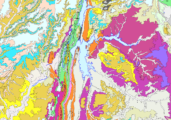
Lithostratigraphic map of Spain at a scale of 1:200.000 continuous digital.


The continuous lithostratigraphic map of Spain in digital format at a scale of 1:200,000 represents the cartographic units characterised mainly according to lithostratigraphic and hydrogeological criteria. The criteria maintained to consider their cartographic representation are to maintain those units that present an important lithostratigraphic development, both for their representation and their singularity, also incorporating those that show a high hydrogeological interest, either because of their lithological nature (high permeability) or because they are considered to form an essential part of the definition of the aquifer. The contacts between the cartographic units represented were normal, unconformable and intrusive contacts. Faults, thrusts and folding structures are represented.
Thus, a continuous map has been obtained in digital format, in which there are still areas with a higher density of cartographic information than others, either because they come from synthesis maps made with less general criteria than these, or because for their preparation, smaller scale cartographies (e.g. 1:50,000) have been used, thus obtaining a much richer and more detailed cartography.
This map is the basis of the permeability and hydrogeological maps of Spain at a scale of 1:200,000 continuous and in digital format.
This cartography is adapted to the hydrographic network and the shadow model made by CEDEX, at a scale of 1:200,000, from the topographic base, at a scale of 1:50,000, of the Army Cartographic Service. The cartographic information is referenced to coordinates in UTM projection, European Datum, zone 30, except for that corresponding to the Canary Islands, which is referenced to zone 28.
The map is made up of the following information layers: Cartographic Units (LPLIT), Contacts and Fractures (LPCYF) and Folding Structures (LPEST).
The format of the information generated is Shape file.
large_thumbnail
dataset
- ?
Link to the GetCapabilities of the web service hosting the product
- Map service (URL of the Capabilities file)
:
637841
Spanish
Geoscientific information
IGME Thesaurus:
CEOLocation:
GEMET:
GEMET - INSPIRE themes, version 1.0:
 Spatial scope:
General geology.geology
Stratigraphy.lithostratigraphy
Hydrology, Hydrogeology, Hydrogeology. hydrogeology
Sedimentología y Petrología sedimentaria.mapa litológico
Stratigraphy.stratigraphic map
General geology.rock
General geology.rock.crystalline rock.igneous rock
General geology.rock.sedimentary rock
Systematics of igneous rocks.plutonic rock
COUNTRIES.SPAIN
NATURAL ENVIRONMENT, ANTHROPIC ENVIRONMENT
HYDROSPHERE (freshwater, seawater, waters)
hydrosphere
water (geography)
groundwater
Free:
Chronostratigraphy
Free:
Permeability
Free:
Groundwater
Free:
DMA
Free:
Groundwater body
Free:
EGDI
-18.167,
27.642,
4.337,
43.793
creation: 2005-09-18, publication: 2007-09-30, revision: 2009-08-05
2009-08-05T00:00:00
completed
vector
Hydrogeological information and maps are needed to define and delimit groundwater bodies with greater precision, so that this information can be used to: indicate the location and limits of groundwater bodies, define the general characteristics of the overlying strata of the catchment area, sources of contamination, etc. And to carry out the additional characterisation of the m.a.s. at risk, where it is necessary to establish their recharge areas, the characteristics of the chemical composition of the water, the location of the groundwater extraction points, the protected areas and their characteristics.
As a preliminary work, the continuous lithostratigraphic map of Spain was produced in digital format, a fundamental starting point for the preparation of the permeability and hydrogeological maps of Spain at a scale of 1:200,000, continuous and in digital format.
All of them were prepared by means of a "Collaboration Agreement between the Ministry of the Environment (General Secretariat for Territory and Biodiversity. Directorate General for Water) and the Geological Survey of Spain for the execution of technical works in relation to the application of the Water Framework Directive on groundwater'' signed in 2004.
Geological Survey of Spain (IGME-CSIC)
Mejías Moreno, Miguel
C/ Ríos Rosas, 23,
Madrid,
28003,
España
tel: +34 91 349 57 00
email:
m.mejias@igme.es
Role: point of contact
Data Quality
The preparation of the lithostratigraphic map involved a series of stages:
1.-Zoning of the Spanish territory according to fundamentally geological and hydrogeological criteria and adapting them to the limits of the topographic sheets at a scale of 1:200,000 established by the IGN.
2.- Compilation of information for each of the zones.
3.- Elaboration of a synthetic chronostratigraphic legend for each of the zones.
4.- Creation of each of the zonal cartographies based on the zonal legends.
5.- Conformation of zones (cases), with the cartographic case of the zones in order to obtain a map without discontinuities.
Elaboration of the lithostratigraphic legend, through the unification and synthesis of all the cartographic terms represented in the zonal legends. Carried out according to chronostratigraphic criteria established in the different geological domains defined for each period in the Spanish territory.
7.- Lithostratigraphic map, made from the lithostratigraphic legend taking into account the scale 1:200,000.
Equivalent Scale:
1:
200000
Constraints
LICENCE OF USE: Conditions of public use and dissemination of information for the re-use of IGME data. https://www.igme.es/condiciones-de-uso/
Metadata about metadata
ESPIGMELITOESTRATIGRAFICO200CONTINUODIGITAL20100804637841
Geological Survey of Spain (IGME-CSIC)
Leticia Vega Martín
C/ Ríos Rosas, 23,
Madrid,
28003,
España
tel: +34 91 349 57 00
email:
l.vega@igme.es
Role: point of contact
2026-02-23
Coupled Resource
(The rock units of the sheet separated by different types of contacts are represented, together with the tectonic structure, faults and map traces of folds, the orientation and dip of planar and linear elements contained in the rocks, structural and textural singularities of igneous and metamorphic rocks, water points, mineral deposits and indications, presence of fossils and other elements of punctual representation.)
(The rock units of the sheet separated by different types of contacts are represented, together with the tectonic structure, faults and map traces of folds, the orientation and dip of planar and linear elements contained in the rocks, structural and textural singularities of igneous and metamorphic rocks, water points, mineral deposits and indications, presence of fossils and other elements of punctual representation.)
(Map with the chronolithostratigraphic units differentiated according to their hydrogeological characteristics divided into impermeable and permeable units distinguished by colours and plots.)