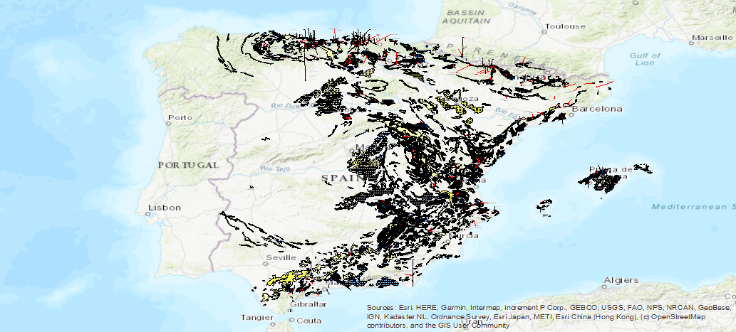
Map of the Spanish Karst on a scale of 1:1,000,000
The Map of the Karst of Spain includes the different 'karstifiable' lithologies indicating their type (carbonates, gypsums and detritus), and the intensity of karstification in each of the areas. Also included are caves, poles, outcrops and other hydrogeological and geomorphological entities linked to karstification processes

large_thumbnail
dataset
Download Karst Map of Spain 1:1.000.000
- Download page from the IGME website
IGME-CSIC
:
ESPIGMEKARST1000
Spanish
Geoscientific information
IGME Thesaurus:
GEMET - INSPIRE themes, version 1.0:
Spatial Scope:
IGME
Karst
Limestone
Dolomite
Gypsum
Groundwater
Aquifer
Spring
Exsurgence
Travertine
Dissolution
Dolines
Cavern
Collapse
Karren
Geomorphology
Natural risk
Spain
Free:
Detritic
Karstification
Polje
Sima
Sinkhole
Torca
Exokarst
Free:
IDEE
Free:
EGDI
-22.71,
25.95,
6.34,
44.70
creation: 1986-01-01
1986-01-01T10:00:00
vector
The main objective of the map of the Karst in Spain is to represent the peninsular surface where karstified carbonate rocks appear, as well as the gypsum outcrops and other types of soluble rocks such as detritic carbonate rocks, and sodium and potassium salts fundamentally. In addition, a large part of the large rivers originate from karstic springs and a large part of the underground aquifers that supply the population, agriculture and livestock are of this nature
Geological Survey of Spain (IGME-CSIC)
Joaquín Mulas de la Peña
,
Madrid,
28003,
España
tel: +34 91 349 58 11 / 91 349 59 52
email:
j.mulas@igme.es
Role: custodian
Data Quality
The map of the Karst in Spain includes a large part of the peninsula and the Balearic Islands where karstified carbonate rocks emerge, as well as gypsum outcrops that also cover a large area and, to a lesser extent, other types of soluble rocks (detritic carbonate rocks, sodium and potassium salts). For the preparation of the karst map, a first selection was made from all the IGME 1:200,000 scale geological synthesis maps (published between 1970 and 1973) of all the potentially karstifiable outcrops existing in our country. Thus, a first approximation map of existing karstifiable materials was composed, whether they were carbonate, gypsum, detritic (only those that we had evidence of in their karstification) or mixed. From this first sketch, successive corrections were made with data from the "Geological Map of the Iberian Peninsula, Balearic and Canary islands" at a scale 1:1,000,000 (IGME -1980), the "Map of Vulnerability to Contamination of the Aquifers of Peninsular Spain, Balearic and Canary Islands" at the same scale (IGME-1972) and the "Hydrogeological Map", also at the same scale, which at that time was being drawn up by the IGME. Later, more and more detailed approximations were made, in certain areas, from hydrogeological, geomorphological and geological maps (MAGNA series), with different working scales, which have gone from 1:50,000 to 1:400,000. Speleological information was also used, such as the 'catalogue of large caves in Spain' (Spanish Federation of Speleology, 1982).
Equivalent Scale:
1:
1000000
COMMISSION REGULATION (EC) No 1205/2008 of 3 December 2008 implementing Directive 2007/2/EC of the European Parliament and of the Council as regards metadata
Constraints
LICENCE OF USE: Conditions of public use and dissemination of information for the re-use of IGME data. https://www.igme.es/condiciones-de-uso/
Metadata about metadata
ESPIGMEKARST100020200714
Geological Survey of Spain (IGME-CSIC)
Leticia Vega Martín
,
Madrid,
28003,
España
tel: +34 91 349 57 00
email:
l.vega@igme.es
Role: point of contact
2025-06-17
Coupled Resource
(First selection of potentially karstifiable outcrops from the IGME 1:200,000 scale geological synthesis maps (published between 1970 and 1973), whether carbonate, gypsum, detritic or mixed, with evidence of their karstification. From this first sketch, successive corrections were made with the data from the "Geological Map of the Iberian Peninsula, Balearic and Canary Islands" at a scale of 1:1,000,000 (IGME -1980), the "Map of Vulnerability to Contamination of the Aquifers of Peninsular Spain, Balearic and Canary Islands" of the same scale (IGME-1972) and the "Hydrogeological Map", also of the same scale, which, at that time, was being drawn up by the IGME. Later, more and more detailed approximations were made, in certain areas, starting from hydrogeological, geomorphological and geological maps (MAGNA series), with different working scales, which have gone from 1:50,000 to 1:400,000. Likewise, speleological information was used, such as the "Catalogue of large caves in Spain" (Spanish Federation of Speleology, 1982).)


