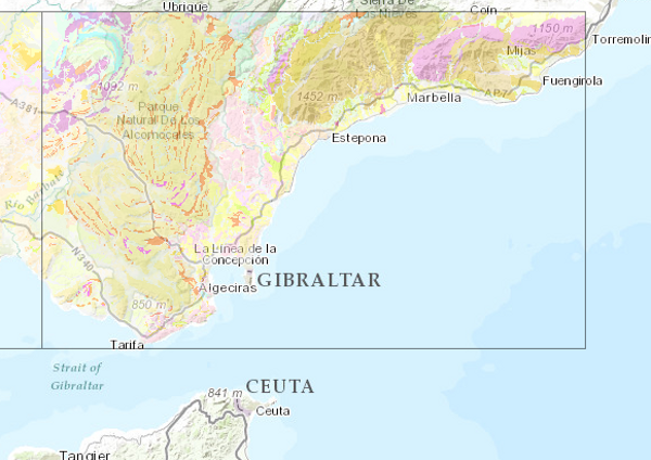
Geological Map of Spain Scale 1:200.000 (2nd series)


This Map depicts the materials or rocks that appear on the surface of the sheet, their spatial distribution, nature and geometric relationships. The cartographic units are chronostratigraphic groupings, with common lithology and age formed by strata which are called formations, groups or members; other non-stratified ones such as granites are represented. The structural relationships between them are expressed by symbols, which gives the map a three-dimensional character completed by additional geological profiles. These are the graphic expression of the deep geometrical arrangement of the units shown on the geological map. Applied information such as water points, mineral deposits and indications, presence of fossils and other elements of point representation are added by means of symbology. The printed sheets include geological sections, columns of the main zones or units and various diagrams (regional geological and tectonic diagrams, both at a scale of 1:1,000,000).
The nominal scale of the series is 1:200,000, but in the island territories it has been produced at a scale of 1:100,000.
The digital information, geological map 1:200,000, chronolithostratigraphic legend and legend of geological symbols, is stored in coverage format (ESRI). There is a guide reflecting its organisation and codification.
IGME is responsible for the execution of this series of cartography, which it finances with its own resources.
Creation of this cartography is based on the compilation of existing information, mainly MAGA cartography at a scale of 1:50,000, doctoral theses and other research work.
series
- Mapa Geológico de España Escala 1:200.000 (2ª serie)
Link to the GetCapabilities of the web service hosting the product
- Map service (URL of the Capabilities file)
IGME-CSIC
:
ESPIGMEGEOLOGICO200
:
22100_Identificador del Centro de documentación
Spanish
Geoscientific information
IGME Thesaurus:
GEMET:
Spatial scope:
European Geoscience Registry - Projects:
GEMET - INSPIRE themes, version 1.0:

General geology.geology
Stratigraphy.lithostratigraphy
Stratigraphy.Chronostratigraphy
General geology.lithology
Systematics of metamorphic rocks.metamorphic rock
General geology.rock.crystalline rock.igneous rock
General geology.tectonite
Structural geology.fault
Structural geology.fold
Systematics of Geography.Spain
General geology.geological map
General geology
rock
sedimentary rock
NATURAL ENVIRONMENT, ANTHROPIC ENVIRONMENT
LITHOSPHERE (soil, geological processes)
lithosphere
rocks
Free:
relief form
Free:
InventoryGM
-18.208,
27.608,
4.315,
43.834
creation: 1981-01-01, publication: 1983-01-01
under development
vector, grid
To create a regional geological knowledge structure from the synthesis of geological mapping on a larger scale. The objective is to provide geological information for regional planning in aspects related to geological resources, geological risks, environmental protection and communication networks.
Alejandro Robador Moreno
C/la Calera s/n,
Tres Cantos,
28760,
España
email:
a.robador@igme.es
Role: point of contact
Data Quality
In summary, it can be said that the cartography of the Geological Map of Spain Scale 1:200.000, 2nd series, is based on the fundamental reference of the Geological Map of Spain Scale 1:50.000, MAGNA, (2nd Series); it begins with the compilation and analysis of the rest of the information related to the area and its surroundings, including topographic bases and other cartographies and related works such as singular projects, doctoral theses, etc. The next step is the study of the cartographic units and the revision of the available map samples, some field revision with the collection of data and samples for later study, simultaneously with some required photogeological interpretation, is the next step. Then, the transfer of the field work to the map and the subsequent elaboration of the map, supported by photo-interpretation works. The elaboration of the text of the report and that of the complementary information and its organisation complete the process.
Finally, the information is digitised.
Supervision, correction and validation following the Institute's digital cartography revision procedure, which consists of error detection and correction controls and thorough visual checks.
Finally, the information is digitised.
Supervision, correction and validation following the Institute's digital cartography revision procedure, which consists of error detection and correction controls and thorough visual checks.
Equivalent Scale:
1:
200000
, 1:
100000
Constraints
LICENSE OF USE: Conditions of public use and dissemination of information for the reuse of data. https://www.igme.es/condiciones-de-uso/
Metadata about metadata
ESPIGMEGEOLOGICO2002009111022100
Leticia Vega Martín
C/Ríos Rosas, 23,
Madrid,
28003,
España
email:
l.vega@igme.es
Role: point of contact
2026-05-22
Coupled Resource
(Process of digitalisation of the information:
Analysis of the entities present in the cartography. Assignment dThe materials or rocks that appear on the surface of the sheet, their spatial distribution, nature and geometric relationships are represented. Mapping units are groupings with common lithology and age formed by strata or other unstratified rocks such as granites. The structural relationships between them are expressed by symbols, which gives the map a three-dimensional character that is completed by additional geological profiles that are the graphical expression of their geometry in depth. Symbology adds information, some of an applied nature such as water points, deposits and mineral indications.)
Analysis of the entities present in the cartography. Assignment dThe materials or rocks that appear on the surface of the sheet, their spatial distribution, nature and geometric relationships are represented. Mapping units are groupings with common lithology and age formed by strata or other unstratified rocks such as granites. The structural relationships between them are expressed by symbols, which gives the map a three-dimensional character that is completed by additional geological profiles that are the graphical expression of their geometry in depth. Symbology adds information, some of an applied nature such as water points, deposits and mineral indications.)