Geological Map of Spain and Portugal at scale of 1:1.000.000


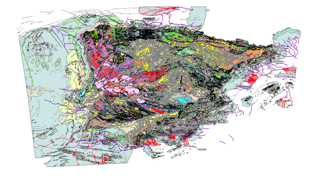
Geological map of Spain and Portugal at scale 1:1 000 000 of 2015 is an updated cartographic version of the Iberian Peninsula as well as Ceuta and Melilla and all the insular territory of Spain and Portugal: Balearic Islands, Canary Islands, Azores and Madeira, published periodically by the IGME in collaboration with the Geological Survey of Portugal (LNEG). This new version includes for the first time the geological cartography of the continental shelf and the Atlantic islands of Portugal. This map includes all the new geological knowledge that has resulted from the completion of the MAGNA series of 1:50,000 scale geological cartography of the IGME for the Spanish territory and the systematic series of cartography of the Portuguese territory developed by the LNEG. The continental part of the map has been composed from previous syntheses at a scale of 1:400,000 developed for each major geological unit in Spain, specifically, the Variscan Massif, the Pyrenees, the Baetic, Cantabrian and Iberian C. and the Cenozoic Basins of the Duero, Tagus and Ebro, and from the geological cartography at a scale of 1:200,000 produced in Portugal.
large_thumbnail
dataset
IGME-CSIC
:
ESPIGMEGEOLOGICO1000ESPANAYPORTUGAL
Spanish, Portuguese
Geoscientific information
European Geoscience Registry - Projects:
EuropeanTerritorialUnits:
GEMET - INSPIRE themes, version 1.0:
 IGME Thesaurus:
GEMET:
Spatial scope:
IGME Thesaurus:
GEMET:
Spatial scope:
Spain
Portugal
Balearic Islands
Canary
Autonomous Region of the Azores
Autonomous Region of Madeira
General geology
Geology
Estratigrafía
Lithostratigraphy
Chronostratigraphy
Lithology
Systematics of metamorphic rocks
Metamorphic rock
rock
Crystalline rock
Igneous rock
Structural geology
Fault
Systematic Geography
Spain
Sedimentary rock
Boundary
Stratigraphy Systematics
Precambrian
Paleozoic
Mesozoic
Cenozoic
Quaternary
NATURAL ENVIRONMENT, ANTHROPIC ENVIRONMENT
LITHOSPHERE (soil, geological processes)
lithosphere
rocks
Free:
IGME
LNEG
Official Geological Cartography
Geological Map
InventoryGM
Free:
Geological units
Geology
Ages
Faults
-32,
27.5,
4.5,
43.75
?
creation: 2015-12-17
2015-12-17T10:00:00
completed
vector
This map represents an update of the geological cartography of the Iberian Peninsula and the entire island territory of Spain and Portugal at a scale of 1:1,000,000, as a synthesis of the improvement of geological knowledge that resulted from the completion of the MAGNA series of geological cartography at a scale of 1:50,000 of the IGME, for the Spanish territory, and the systematic series of cartography of the Portuguese territory developed by the LNEG. It includes for the first time the geological mapping of the continental shelf and that of the Portuguese Atlantic islands.
Geological Survey of Spain (IGME-CSIC)
?
?,
Tres Cantos,
28760,
?
tel: +34 91 728 72 50
email:
a.robador@igme.es
Role: publisher
Laboratório Nacional de Energia e Geologia, I.P.
?
?,
Amadora,
2610-999 Amadora,
?
tel: (+351) 210 924 600
email:
cartografia@lneg.pt
Role: point of contact
Data Quality
The Geological Map of Spain and Portugal at a scale of 1:1 000 000 was compiled from various sources. The continental part of the map was compiled from previous 1:400,000 scale syntheses prepared for each of the major geological units in Spain, namely the Variscan Massif, the Pyrenees, the Betic Cordillera, the Cantabrian and Iberian Cordillera and the basins of the Duero, Tagus and Ebro rivers, and the 1:200,000 scale geological cartography carried out in Portugal. A group of experts simplified this initial information and compiled it according to the common legend defined for the map. The mapping of the Spanish islands was elaborated from the original information of the IGME cartographic series at various scales and the geological mapping at scales 1:25 000 and 1:50 000 for the Portuguese Atlantic islands. The geological mapping of the continental margin was elaborated from several cartographic sources at different scales: Geological Maps of the Spanish Continental Shelf at scale 1:200 000 and the Geological Map of the Quaternary at scale 1:1 000 000 published by the IGME, the Geological Map of Portugal at scale 1:1 000 000 000 (LNEG-LGM) including the new version of the Geological Map of the Portuguese Continental Shelf at scale 1:2 000 000 000 and the Geological Map of the Bay of Biscay (BRGM). This cartography was complemented with geological data acquired in oceanographic campaigns carried out in the framework of different research projects with the participation of the IGME and the LNEG, as well as the Spanish Continental Shelf Expansion Project, in accordance with the United Nations Convention on the Law of the Sea.
Equivalent Scale:
1:
1000000
Commission Regulation (EC) No 1205/2008 of 3 December 2008 laying down detailed rules for the implementation of Directive 2007/2/EC of the European Parliament and of the Council as regards metadata
Constraints
Metadata about metadata
ESPIGMEGEOLOGICO1000ESPANAYPORTUGAL20180427
Geological Survey of Spain (IGME-CSIC)
Leticia Vega Martín
C/Ríos Rosas, 23,
Madrid,
28003,
España
email:
l.vega@igme.es
Role: point of contact
2026-05-22
Coupled Resource
(The rock units of the sheet separated by different types of contacts are represented, together with the tectonic structure, faults and map traces of folds, the orientation and dip of planar and linear elements contained in the rocks, structural and textural singularities of igneous and metamorphic rocks, water points, mineral deposits and indications, presence of fossils and other elements of punctual representation..)
(The rock units of the sheet separated by different types of contacts are represented, together with the tectonic structure, faults and map traces of folds, the orientation and dip of planar and linear elements contained in the rocks, structural and textural singularities of igneous and metamorphic rocks, water points, mineral deposits and indications, presence of fossils and other elements of punctual representation.)
(Geological Map of the Spanish Continental Shelf at a scale of 1:200 000 (IGME))
(Geological Map of Catalonia, scale 1:250 000)
(Geological Mining Map of Andalucia 1:400.000)
(Geological Map of Portugal at a scale of 1:500 000 (SGP, 1992))
(Geological Map of the Iberian Peninsula, Balearic and Canary Islands, scale 1:1 000 000, 1995 edition.)
(Geological Map of Portugal at scale 1:1 000 000 (LNEG-LGM, 2010))
(The Map contains the chronolithostratigraphic units separated by undifferentiated geological contacts and the tectonic structure represented by faults and thrusts.)
(The Map contains the chronolithostratigraphic units separated by undifferentiated geological contacts and the tectonic structure represented by faults and thrusts.)
(The map shows the chronostratigraphic units bounded by undifferentiated geological boundaries and the geological structure represented by faults and thrusts.)