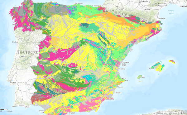
Geological Ages Map of the Iberian peninsula, Balearic and Canary Islands at scale 1:1.000.000


The Map of Geological Ages of the Iberian Peninsula, Balearic and Canary Islands at a scale of 1:1,000,000 is a map produced by the Geological Survey of Spain (IGME) based on the Geological Map of the Iberian Peninsula, Balearic and Canary Islands published in 1995.
The cartographic units represented in it have been established by means of chronostratigraphic criteria, which have been specified down to the Series. The chronostratigraphic classification used was the "International Stratigraphic Chart" published in 2008 and drawn up by the International Commission on Stratigraphy of the International Union of Geological Sciences (IUGS).
The igneous and metamorphic rocks have been assigned the corresponding chronostratigraphic section.
The geological information for the Iberian Peninsula and the Balearic Islands is in UTM projection, zone 30, Postdam datum. The information on the Canary Islands is in UTM projection, zone 28, datum Pico de las Nieves.
The map is distributed free of charge in shape format.
large_thumbnail
series
- Mapa de Edades Geológicas de la Península Ibérica, Baleares y Canarias a escala 1:1.000.000
Link to the GetCapabilities of the web service hosting the product
- WMS access to information layers.
:
260472
Spanish
Geoscientific information
IGME Thesaurus:
CEOLocation:
GEMET:
GEMET - INSPIRE themes, version 1.0:
 Spatial scope:
General geology
geology
Sistemática de Estratigrafía
Proterozoic
Vendiense
Lower Palaeozoic
Cambrian
Ordovician
Devonian
Carboniferous
Mesozoic
Triassic
Jurassic
Cretaceous
Palaeogene
Neogene
COUNTRIES.SPAIN
NATURAL ENVIRONMENT, ANTHROPIC ENVIRONMENT
LITHOSPHERE (soil, geological processes)
lithosphere
rocks
Free:
Quaternary
Free:
Rifeense
Free:
Spain
Free:
EGDI
-18.25,
27.5,
4.5,
43.5
creation: 2009-05-31, publication: 2009-06-30
2009-05-31T10:00:00
completed
vector
The Geological Ages map of the Iberian Peninsula, Balearic and Canary Islands has been generated as a contribution to the OneGeology initiative that aims to create a geological map of the world from national maps under interoperability standards. This map complements the map of Lithologies of the Iberian Peninsula, Balearic and Canary Islands...
Geological Survey of Spain (IGME-CSIC)
Alejandro Robador Moreno
C/la Calera s/n,
Tres Cantos,
28760,
España
tel: +34 91 349 57 00
email:
a.robador@igme.es
Role: point of contact
Data Quality
The map of Geological Ages was drawn up on the basis of the Geological Map of the Iberian Peninsula, Balearic and Canary Islands at a scale of 1:1,000,000, 1995 edition.
Each geological unit was assigned the System or set of Systems it encompasses, established in the chronolithostratigraphic legend. Finally, the new cartographic units were generated from the common geological age.
Each geological unit was assigned the System or set of Systems it encompasses, established in the chronolithostratigraphic legend. Finally, the new cartographic units were generated from the common geological age.
Equivalent Scale:
1:
1000000
Constraints
LICENCE OF USE: Conditions of public use and dissemination of information for the re-use of IGME data. https://www.igme.es/condiciones-de-uso/
Metadata about metadata
ESPIGMEEDADESGEOLOGICAS100020100903260472
Instituto Geológico y Minero de España (IGME-CSIC)
Leticia Vega Martín
C/ Ríos Rosas, 23,
Madrid,
28003,
España
tel: +34 91 349 57 00
email:
l.vega@igme.es
Role: point of contact
2025-06-17
Coupled Resource
(The map contains the chronolithostratigraphic units separated by undifferentiated geological contacts and the tectonic structure represented by faults and thrusts.)