International Hydrogeological Map of Europe 1:1,500,000 (IHME1500) (WMS)


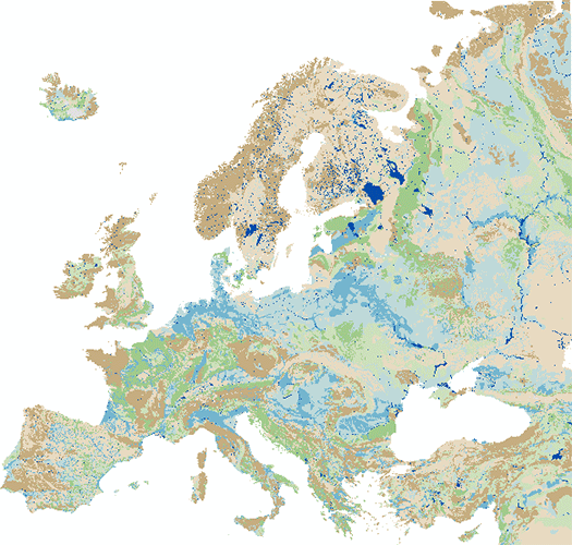
The IHME1500 v1.2 is a vector dataset resulting from the digitisation of the 25 published map sheets of the International Hydrogeological Map of Europe at the of scale 1:1,500,000 (IHME1500). The dataset was extended for five unpublished, digitised IHME1500 map sheets to achieve full map coverage. It consists of selected features of the IHME1500 with the following content: - Aquifer types (area): Distinction of six types of aquifers according to their productivity and void types. - Lithology (area): Lithological classification of the aquifers at five aggregation levels. - Seawater intrusion (area): Areas with salination of groundwater caused by sea water intrusion. - Tectonic fractures (line): Geological lineaments assigned to the five classes of known or supposed faults or overthrusts and boundaries of fractured belts in Iceland. The IHME1500 v1.2 includes a correction of inconsistencies of the printed map sheets and was spatially adjusted to an up-to-date topographic base. The IHME1500 is a hydrogeological map series consisting of 25 published map sheets with explanatory notes that covers the European continent and parts of the Near East. The Federal Institute for Geosciences and Natural Resources (BGR) and the United Nations Educational, Scientific and Cultural Organization (UNESCO) are the project coordinators, supported by the International Association of Hydrogeologists (IAH) and the Commission for the Geological Map of the World (CGMW). Each sheet consists of contributions by the respective countries represented in the map, which were harmonised across borders. The map series including the explanatory notes can be used for scientific purposes, for large-scale regional planning and as a framework for detailed hydrogeological mapping.
service
- Grundwasser
:
374D0FC8-0C23-4B2E-AFBA-9A8565C1C0A5
view
OGC:WMS 1.3.0
GEMET - INSPIRE themes, version 1.0:
GEMET - Concepts, version 2.4:
SGD-Liste:
Geologie
Geology
Grundwasser
Hydrogeologie
Aquifer
Free:
Groundwater resources
Grundwasservorkommen
infoMapAccessService
Lithologie
Lithology
Quellen
Springs
IHME
ihme
EGDI
ihme1500
ihme 1500
Free:
Europäischer Kontinent und Teile des Nahen Ostens
-63.715,
25.193,
79.8,
76.515
revision: 2019-08-01
onGoing
Bundesanstalt für Geowissenschaften und Rohstoffe
Dr. Andreas Günther
,
DE
email:
fis.hy@bgr.de
Role: point of contact
Bundesanstalt für Geowissenschaften und Rohstoffe (BGR)
email:
geodatenmanagement@bgr.de
Role: custodian
Data Quality
Constraints
Allgemeine Geschäftsbedingungen (AGB) der Bundesanstalt für Geowissenschaften und Rohstoffe (BGR). Bei Software, digitalen Daten und sonstigen urheberrechtlich geschützten Werken sowie Know-how ist das LBEG bzw. die BGR Inhaber der Verwertungsrechte. Der Vertragspartner erhält ein einfaches Nutzungsrecht für die im Folgenden beschriebenen Nutzungsarten. Übertragen wird das Recht zur Vervielfältigung und Vorführung. Nicht übertragen wird insbesondere das Recht der öffentlichen Zugänglichmachung, es sei denn der Vertragspartner nimmt die öffentliche Zugänglichmachung als beteiligte Behörde eines Verwaltungsverfahrens für Zwecke des Verwaltungsverfahrens vor. Die bereitgestellten Informationen sind bei Weiterverwendung wie folgt zu zitieren: Datenquelle: IHME1500 v1.2 (C) BGR & UNESCO 2019
Metadata about metadata
E0BF7822-2327-4C64-90B8-2CC522103FBB
Bundesanstalt für Geowissenschaften und Rohstoffe (BGR)
,
DEU
email:
geodatenmanagement@bgr.de
Role: point of contact
2024-01-23