Geological Map of Germany 1:1,000,000 (WMS)


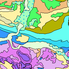
The Geological Map of Germany 1:1,000,000 (GK1000) represents the geology of Germany and adjacent areas. The Quaternary units of Northern Germany and the Alpine foreland are described by their genesis.The older sedimentary rocks are classified by age (stratigraphy); igneous and metamorphic rocks are classified by their composition (lithology).
service
- Geologie
:
029AD1B5-6431-400B-90EF-F1B0F424FD8C
view
OGC:WMS 1.3.0
GEMET - INSPIRE themes, version 1.0:
GEMET - Concepts, version 2.4:
SGD-Liste:
Geologie
Geology
Gebirge
Geowissenschaften
Gestein
Kalkstein
Kartierung
Meeressediment
Moor
Sand
Sedimentation (geologisch)
Tektonik
Verwerfung
Deckgebirge
Festgestein
Gabbro
Genese
Granit
Kristallingestein
Küstengeologie
Lockergestein
Petrographie
Quartärgeologie
Sedimentgestein
Störung
Stratigraphie
Free:
Entstehung
Gesteinsalter
Gesteinsart
infoMapAccessService
EGDI
sgd_Geologie
GeolDG
Free:
Bundesrepublik Deutschland
5.391,
46.674,
15.514,
55.649
publication: 1993-03-16, revision: 2008-08-01
completed
Bundesanstalt für Geowissenschaften und Rohstoffe
Wiechmann, Marc Filip, Dr.
Stilleweg 2,
Hannover,
30655,
DE
email:
geologie.daten@bgr.de
Role: point of contact
Bundesanstalt für Geowissenschaften und Rohstoffe (BGR)
email:
geodatenmanagement@bgr.de
Role: custodian
Data Quality
Constraints
Allgemeine Geschäftsbedingungen, siehe https://www.bgr.bund.de/AGB - General terms and conditions, see https://www.bgr.bund.de/AGB_en. Die bereitgestellten Informationen sind bei Weiterverwendung wie folgt zu zitieren: Datenquelle: GK1000, (c) BGR Hannover, 2014
Metadata about metadata
ADB575F8-6BA6-48B6-A1EB-9D5980935F37
Bundesanstalt für Geowissenschaften und Rohstoffe (BGR)
,
DEU
email:
geodatenmanagement@bgr.de
Role: point of contact
2024-03-04