General Geological Map of the Federal Republic of Germany 1:200,000


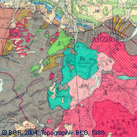
The map series General Geological Map of the Federal Republic of Germany 1:200,000 (GÜK200) is the result of cooperation between the State Geological Surveys of the Federal Republic of Germany (SGD), the Geological Surveys of neighbouring countries and the Federal Institute for Geosciences and Natural Resources (BGR). The GÜK200 displays the surface geology of Germany and adjacent areas of neighbouring countries on 55 map sheets. The map sheets show the regional dissemination of more than 3800 geological units. The geological units contain information on stratigraphy (age), genesis and petrography (composition) of the rocks. Each printed/scanned map sheet contains one or several geological cross-sections which give an insight into the subsurface. The digital data of the map series are stored separately for each map sheet. According to this geological units/polygons, their boundaries, tectonic linear elements and, if present, ice sheet boundaries are saved as a discrete layer in a shapefile for the single map sheets. The attributes of the geological units contain information – like in the printed map sheets – on stratigraphy, genesis and petrography of the rocks.
series
- Geologie
:
57208E6C-27D2-41CB-8F7A-8B9091737855
German
Geoscientific information
GEMET - INSPIRE themes, version 1.0:
Spatial scope:
High-value dataset categories:
Geology
Geologie
National
Erdbeobachtung und Umwelt
Free:
Allgemeine Geologie
inspireidentifiziert
EGDI
opendata
Free:
Deutschland
5.5,
47.25,
15.5,
55.2
000000000000
publication: 2007-03-09
completed
grid, vector
Bundesanstalt für Geowissenschaften und Rohstoffe
Stilleweg 2,
Hannover,
30655,
DE
email:
geologie.daten@bgr.de
Role: point of contact
Data Quality
-
Equivalent Scale:
1:
200000
VERORDNUNG (EG) Nr. 1089/2010 DER KOMMISSION vom 23. November 2010 zur Durchführung der Richtlinie 2007/2/EG des Europäischen Parlaments und des Rates hinsichtlich der Interoperabilität von Geodatensätzen und -diensten
Constraints
Allgemeine Geschäftsbedingungen, s. https://www.bgr.bund.de/agb - General Terms and Conditions, s. https://www.bgr.bund.de/agb_en
Dieser Datensatz kann gemäß der "Nutzungsbestimmungen für die Bereitstellung von Geodaten des Bundes" (https://sg.geodatenzentrum.de/web_public/gdz/lizenz/geonutzv.pdf) genutzt werden.
{"id": "geoNutz/20130319", "name": "Nutzungsbestimmungen für die Bereitstellung von Geodaten des Bundes", "url": "https://sg.geodatenzentrum.de/web_public/gdz/lizenz/geonutzv.pdf", "quelle": "Bundesanstalt für Geowissenschaften und Rohstoffe (BGR)"}
Metadata about metadata
ABA9633F-E0BA-438D-918C-6B3BEB4D641C
Bundesanstalt für Geowissenschaften und Rohstoffe (BGR)
,
DEU
email:
geodatenmanagement@bgr.de
Role: point of contact
2026-01-13