The 1:5 Million International Geological Map of Europe and Adjacent Areas (IGME5000)


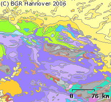
The 1:5 Million International Geological Map of Europe and Adjacent Areas shows the pre-Quaternary geology of Europe onshore and offshore. In addition to the geology attributed by age, petrography and genesis, also magnetic anomalies, tectonic structures, metamorphism and – in the offshore areas – information about the continental/oceanic crust and the continental margin, are shown. The map was developed by BGR under the umbrella of the Commission of the Geological Map of the World (CGMW) and in cooperation with geological surveys organisations of 48 countries and more than 20 research institutes. For detailed information about the 'IGME 5000: More than just a map – A multinational GIS Project' please visit the IGME website.
dataset
- Geologie
IGME5000 (PDF)
- IGME5000 im Format Adobe Acrobat Datei (96 dpi)
IGME5000 (JPEG)
- IGME5000 im Format JPEG (Auflösung 150 dpi)
IGME5000 (TIFF)
- IGME5000 im Format TIFF (Auflösung 300 dpi)
IGME5000 (gedruckt)
- IGME5000 im Format gedruckt, gefalzt
IGME5000 (Shapefile)
- IGME5000 im Format ESRI Shape
:
2AA264D3-CB08-4BEC-83F3-996ED3D8A314
:
https://doi.org/10.25928/igme-5000
English
Geoscientific information
GEMET - INSPIRE themes, version 1.0:
High-value dataset categories:
Geologie
Geology
Erdbeobachtung und Umwelt
Free:
Europa
Free:
EGDI
igme5000
GeolDG
opendata
-70,
21,
100,
80
publication: 2005-11-21
completed
grid, vector
Bundesanstalt für Geowissenschaften und Rohstoffe
Asch, Kristine, Dr.
Stilleweg 2,
Hannover,
30655,
DE
email:
geologie.daten@bgr.de
Role: point of contact
Data Quality
Die Karte entstand unter der Leitung der BGR und der Schirmherrschaft der Weltkartenkommission (CGMW) mit Beiträgen von 48 europäischen geologischen Diensten und mehr als 20 wissenschaftlichen Institutionen. - Manuscripts done by the National Geological Survey Organisations of the involved European countries
Equivalent Scale:
1:
5000000
VERORDNUNG (EG) Nr. 1089/2010 DER KOMMISSION vom 23. November 2010 zur Durchführung der Richtlinie 2007/2/EG des Europäischen Parlaments und des Rates hinsichtlich der Interoperabilität von Geodatensätzen und -diensten
Constraints
Allgemeine Geschäftsbedingungen, s. https://www.bgr.bund.de/agb - General Terms and Conditions, s. https://www.bgr.bund.de/agb_en
Preis der gedruckten Karte: 18,22 EUR (zzgl. 7% MWSt. und Versandkosten) Weitere Informationen zur Bestellung beim Internationalen Landkartenhaus siehe https://www.bgr.bund.de/produktcenter-bestellhinweis-ILH
Dieser Datensatz kann gemäß der Lizenz "Nutzungsbestimmungen für die Bereitstellung von Geodaten des Bundes" (https://sg.geodatenzentrum.de/web_public/gdz/lizenz/geonutzv.pdf) genutzt werden.
{ "id": "geonutz/20130319", "name": "Nutzungsbestimmungen für die Bereitstellung von Geodaten des Bundes", "url": "https://sg.geodatenzentrum.de/web_public/gdz/lizenz/geonutzv.pdf", "quelle": "IGME5000, BGR" }
Metadata about metadata
9FD6624C-0AA7-46D4-9DA3-955E558CD5F1
Bundesanstalt für Geowissenschaften und Rohstoffe (BGR)
,
DEU
email:
geodatenmanagement@bgr.de
Role: point of contact
2026-01-13