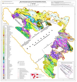
Metallogenic Map of the Republic of Srpska


Metallogenic map of the Republic of Srpska represents the basis for assesing the ore potential and prospect of particular territory in order to increase the degree of economy and effectiveness of future geological researches metallic and non-metallic mineral raw materials and solid fossil fuels of the Republic of Srpska. The basis for preparation of this Metallogenic Map is the Formational Geological Map of the same scale which was created on the basis of the Basic Geological Map of SFRY 1:100 000, the Geological Map of the Republic of Srpska 1:300 000, the Map of Mineral Resources 1:300 000 and the archive of the Geological Survey of the Republic of Srpska. There is also the Interpreter for this map.
dataset
https://data.rzzgi.bh/id/MMRS300
English, Serbian
Geoscientific information
GEMET - INSPIRE themes, version 1.0:
 Spatial scope:
GeoERA Keyword Thesaurus:
Spatial scope:
GeoERA Keyword Thesaurus:
Free:
metallogenic map
economic geology
raw materials
16.194,
42.539,
19.666,
45.293
publication: 2019
2014
-
2019
vector
Long-Term Program for Development of Basic Geological Explorations of the Republic of Srpska
Geological Survey of the Republic of Srpska (RZZGI)
Dražan Tokanović
Vuka Karadzica 148 B, Zvornik,
75400,
Bosnia and Herzegovina
tel: +387 56 210 413
email:
d.tokanovic@geozavodrs.com
Role: custodian
Data Quality
The Metallogenic Map of the Republic of Srpska 1:300 000 and its accompanying Interpreter were developed in accordance with the Long-Term Program for the Development of Basic Geological Research of the Republic of Srpska. For the creation of the Metallogenic Map of the Republic of Srpska 1:300 000 the Manual was used, which prescribed guidelines for the graphical representation of zones of spatial distribution of metallogenic or mineralogenic units. As outlined in the Manual, the creation of the Metallogenic Map of the Republic of Srpska 1:300 000 was conducted in three phases: The first phase involved data collection, synthesis, and analysis, the second phase pertained to the production of the graphical part of the map, while the third phase encompassed the development of the Interpreter for the Metallogenic Map of the Republic of Srpska 1:300 000.
Equivalent Scale:
1:
300000
Constraints
Metadata about metadata
66168585-e834-4bba-b37e-42800a010855
Geological Survey of the Republic of Srpska (RZZGI)
Dražan Tokanović
Vuka Karadzica 148 B, Zvornik,
75400,
Bosnia and Herzegovina
tel: +387 56 210 413
email:
d.tokanovic@geozavodrs.com
Role: point of contact
2024-04-10