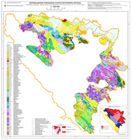
Formational Geological Map of the Republic of Srpska


The Formational Geological Map of the Republic of Srpska 1:300 000, represent a thematic clear geological map, on which the basis mapping unit is formation and which also representing one of the fundamental geological concepts. The Geological Maps of the Republika of Srpska 1: 300 000 and the accompanying interpreter, maps and interpreters of the OGK SFRY 1: 100 000 which covers the territory of the Republic of Srpska as well as the latest results printed in publications or presented at conferences and congresses were used as the basis for preparing this map. The study and knownledge about geological formations is essential for mineral researches, engeenering geology, hydrogeology as well as enviromental protects.
dataset
https://data.rzzgi.bh/id/FGMRS300
English, Serbian
Geoscientific information

16.194,
42.539,
19.666,
45.293
publication: 2019
2014
-
2019
vector
Long-Term Program for Development of Basic Geological Explorations of the Republic of Srpska
Geological Survey of the Republic of Srpska (RZZGI)
Dražan Tokanović
Vuka Karadzica 148 B, Zvornik,
75400,
Bosnia and Herzegovina
tel: +387 56 210 413
email:
d.tokanovic@geozavodrs.com
Role: custodian
Data Quality
After the completion of the Basic Geological Map of the Socialist Federal Republic of Yugoslavia (1:100 000), work shifted towards creating the Formation Geological Map of the Socialist Federal Republic of Yugoslavia. Following the dissolution of the former Yugoslavia, the former member states continued to work on producing this map for their territories. After the completion of the Basic Geological Map of the Republic of Srpska (1:300 000), the creating of the Formation Geological Map began in accordance with the Long-Term Program for the Development of Basic Geological Research of the Republic of Srpska. In addition to the Geological Map of the Republic of Srpska (1:300,000) and the Interpreters, during the production, an unpublished Guide for processing various stratigraphic maps into Formation was used, as well as the latest results published in publications or presented at conferences and congresses relating to geological research of the territory of the Republic of Srpska.
Equivalent Scale:
1:
300000
Constraints
Metadata about metadata
6616667d-c5f4-46aa-a56b-23db0a010855
Geological Survey of the Republic of Srpska (RZZGI)
Dražan Tokanović
Vuka Karadzica 148 B, Zvornik,
75400,
Bosnia and Herzegovina
tel: +387 56 210 413
email:
d.tokanovic@geozavodrs.com
Role: point of contact
2024-04-11