Hydrogeological Map of the Republic of Srpska


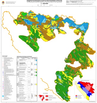
The Hydrogeological Map of the Republic of Srpska 1:300.000 in its widest sense is a graphical representation of hydrogeological characteristics of the territory of the Republic of Srpska. Its preparation is based on the synthesis of the existing geological structure data, hydrogeological categorization of the rocks and hydrogeological regionalization of the Republic of Srpska. The Clear Hydrogeological Map is prepared using modern sofware – programs and tools of the GIS, which enable the creation of hydrogeological data bank as a component of the unique Geological Information System of the Republic of Srpska.
dataset
https://data.rzzgi.bh/id/HG300
English, Serbian
Geoscientific information
GEMET - INSPIRE themes, version 1.0:
 Spatial scope:
GeoERA Keyword Thesaurus:
Spatial scope:
GeoERA Keyword Thesaurus:
Free:
hydrogeological map
16.194,
42.539,
19.666,
45.293
publication: 2016
2014
-
2016
vector
Long-Term Program for Development of Basic Geological Explorations of the Republic of Srpska
Geological Survey of the Republic of Srpska (RZZGI)
Dražan Tokanović
Vuka Karadzica 148 B, Zvornik,
75400,
Bosnia and Herzegovina
tel: +387 56 210 413
email:
d.tokanovic@geozavodrs.com
Role: custodian
Data Quality
The Hydrogeological Map of the Republic of Srpska 1:300 000 has been prepared in accordance with the Long-term Program for the Development of Basic Geological Research of the Republic of Srpska. This map represents one of the strategic interests of the Republic of Srpska as it can be directly used for the development of spatial plans for the Republic of Srpska and its municipalities, providing valuable data for planning and design in mining, water management, hydroenergy, and planning in the areas of land reclamation, use and protection of groundwater, water supply, as well as in other spatial planning and environmental protection, education, and science. The preparation of this map is mainly based on the synthesis of existing data and the results of previous hydrogeological research in the territory of the Republic of Srpska. It was created in accordance with modern Geographic Information System (GIS) software programs, and the water features and objects contained in this map are an integral part of the Hydrogeological Data Bank (HDB) of the Geological Information System of the Republic of Srpska (GeoIISRS), the formation and updating of which are carried out by the Geological Survey of the Republic of Srpska.
Equivalent Scale:
1:
300000
Constraints
Metadata about metadata
66152c67-f474-4277-a680-21a60a010855
Geological Survey of the Republic of Srpska (RZZGI)
Dražan Tokanović
Vuka Karadzica 148 B, Zvornik,
75400,
Bosnia and Herzegovina
tel: +387 56 210 413
email:
d.tokanovic@geozavodrs.com
Role: point of contact
2024-04-11