GEMAS Geochemical Mapping of Agricultural and Grazing Land Soil Europe WGS84

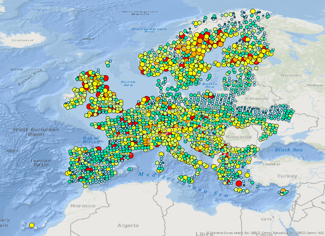
Soil is the outside layer of Earth. It is a made up of living organisms, gases, minerals, and organic matter. Knowing what elements are in the soil helps to work out where it came from and how it was made. The GEMAS (geochemical mapping of agricultural soils and grazing land of Europe) project provides harmonised geochemical data of arable land and land under permanent grass cover across Europe. Geological Surveys in 34 European countries collected soil samples. Soil samples were taken on arable land from the top 0–20 cm of the soil and land under permanent grass cover from the top 0–10 cm. One sample was taken per 2500 km2. The total area covered was 5.6 million km2. Sampling took place during 2008, and early 2009 following a jointly agreed field protocol. All samples were sent to the same lab to be tested for the chemicals that make up the soil. This was done using two different methods. The Aqua Regia (AR) method was used to extract 52 chemical elements and the X-ray Fluorescence (XRF) method was used to extract 41 chemical elements. Soil properties such as Cation exchange capacity (CEC), Total organic carbon (TOC) and pH (calcium chloride - CaCl2). In addition, the agricultural soil samples were analysed for 57 elements in a mobile metal ion (MMI®) extraction, Lead (Pb) isotopes and magnetic susceptibility. Knowing the types of elements in the soil can point to where they came from and how the soils were made. CEC, pH and TOC tell us about the soil's ability to hold onto essential nutrients, how acid or basic the soils are, and the amount of organic carbon in the soil. When the data is mapped, you can see the spread of elements across Europe. This allows the mapping of different soil types. Shallower soil is worth testing as it is good for showing us if any of the changes were caused by the actions of humans. It is also good for farming and the health of soil. It is a vector dataset. Vector data portray the world using points, lines, and polygons (areas). The data is shown as points, which shows where the sample was collected and the results for that sample.
dataset
INSPIRE UUID
:
GE.IE.GSI.GEMAS
English
Environment
Geoscientific information
Geoscientific information
GEMET - INSPIRE themes, version 1.0:
 Spatial scope:
European Geoscience Registry - Projects:
GEMET - Concepts, version 3.1:
Geonames:
GEMET - Concepts, version 3.1:
U.S. Geological Survey Thesaurus:
Spatial scope:
European Geoscience Registry - Projects:
GEMET - Concepts, version 3.1:
Geonames:
GEMET - Concepts, version 3.1:
U.S. Geological Survey Thesaurus:
soil, groundwater, water (geographic), land, metal, chemical
Ireland, Europe
pedosphere, lithosphere
geochemistry, soil chemistry, agriculture
Free:
Soil, Geochemistry, Agricultural, Grazing, land, XRF, X-Ray Fluorescence, Sample, Aqua Regia, AR, MMI, mobile metal ion
-25.131,
25.096,
55.377,
72.479
creation: 2016-10-10, publication: 2016-10-04
2008-01-01
-
2009-06-30
vector
This data shows the type and the amount of chemicals in soil across Europe. The chemicals in the soil can be natural or made by humans. The data also tells us how much organic carbon is in the soil and the pH of the soil. Testing these soils helps us learn about where they came from or how they were made. This data allows us to map both the changing values of these chemicals and soil types across Europe. Knowing about the chemistry of soils is important for many people and industries. This data will help in land-use planning, mapping of natural resources, help to understand the impact of farming on the environment, and aid policy. Higher amounts of some chemicals in soils may also affect human and livestock health. Farmers need to know the chemistry of their soils to understand the quality and fertility of the soils. This helps them decide if they should use fertilisers or not. This can improve the health of their animals and quality of their crops. Soils can affect the quality of drinking water. If the quality of water is affected, it may need to be treated before people or animals can drink it. The chemistry of soils can also help people looking for minerals. Minerals are materials taken from the ground used for things we need from mobile phones to the stones used to build roads and houses.
Geological Survey Ireland
Tellus Project Manager
Block 1, Booterstown Hall, Booterstown, Blackrock,
Dublin,
A94 N2R6,
Ireland
tel: +353-1-6782000
email:
support@geodata.gov.ie
Role: point of contact
Data Quality
The GEMAS project started in 2008 and delivered a book publication on results in December 2013. Sources of Information: GEMAS project, involving 33 European countries, is a cooperation project between EuroGeoSurveys through its Geochemical Expert Group, and Eurometaux, the European Association of Metals. http://gemas.geolba.ac.at/ Please read the Field Protocol Report describing how the data was collected. https://www.ngu.no/upload/Publikasjoner/Rapporter/2008/2008_038.pdf In 2016 the Geological Survey Ireland as a European partner in GEMAS and EGDI (European Geological Data Infrastructure) published an ESRI REST and WMS service to support European data interoperability for the EGDI web portal. ArcGIS 10.1, ArcSDE and ArcGIS Server were used to publish the data. The services were republished using ArcGIS Enterprise in 2024. Metadata was updated to the new GSI standard based on INSPIRE and ISO 19115-3 standards. Plain English is used for the Abstract and Description.
Equivalent Scale:
1:
1000000
Constraints

Metadata about metadata
399663a7-0941-45a3-8952-28bbae54a5b6
Geological Survey Ireland
Information Management
Block 1, Booterstown Hall, Booterstown, Blackrock,
Dublin,
A94 N2R6,
Ireland
tel: +353-1-6782000
email:
support@geodata.gov.ie
Role: point of contact
2026-05-27